
<- Previous Post (Intro) | Next Post (Day 2) ->
"As I make my slow pilgrimage through the world, a certain sense of beautiful mystery seems to gather and grow". A. C. Bensonkey.
-
- Introduction (this is the same as on previous posts, so skip to next section if you’ve already seen it)
- The statistics and metrics of the day
- Stage 01: From Winchester Cathedral to the Cricketers Pub in Alresford
- Stage 02: From the Cricketers Pub in Alresford to the Alton House Hotel in Alton
- Stage 03: From the Alton House Hotel in Alton to the Bishops Table Hotel in Farnham
OK, if this is the first Pilgrim’s Way post of mine that you are reading, I’d recommend you go back a little and read my Introduction to the Pilgrims’ Way blog. There are a few things I explain there that I don’t here and this post might look confusing if you don’t know these things beforehand (e.g. why 15 stages?).
This post is all about the first day of the pilgrimage – but do take into consideration I was cycling, so if you are walking it is likely you’ll cover much less ground than me! In this one day I covered stages 1, 2 and 3 and I describe them separately here. The section below provides the statistics for the full day, but in each video, there are some statistics for each one of the stages such as distance and time.

I reckon that the videos show the route and the difficulties quite well, despite being so speeded-up. You can pause them for more detail or reduce the playback speed in the YouTube interface, if you don’t mind watching it for a longer time (if you do this, don’t forget to mute the video to avoid hearing a slowed-down version of the music!).
Also, bear in mind that this pilgrimage was undertaken during the pandemic and that, although some restrictions had been lifted in the UK in August/September, many places, such as small community churches, were still closed.
Statistics and metrics of the day
All of the details below are in my Pilgrims’ Way Google Sheets Spreadsheet.
- Date: Monday, 31 August 2020 (a bank holiday)
- Route: From Winchester Cathedral to the Bishops Table Hotel, Farnham.
- Distance: 59.63 km
- Departure time from Winchester: Around 11:20h.
- Arrival at Farnham: Around 19:45h.
- Duration of day’s Journey: 4h 54min
- Expenses this day: Total = £95.00
- £30.00 for food.
- £65.00 – Accommodation
- Overnight Location: Bishops Table Hotel, Farnham, Hamsphire, England. ✆ +44 1252 710 222
- Type of Accommodation: Hotel
- Walking the Pilgrims’ Way Guide (Leigh Hatts) Stages:
- Physical and Body Stats: Link to the Garmin Connect Page for this ride
-
- Duration (elapsed time): 04h 54min
- Moving time: 4h 36min
- Average Speed: 12.2 Km/h
- Average Moving Speed: 13 Km/h
-
- Max. Speed: 49.5 Km/h
- Total Elevation Gain: 594 m
- Average Heart Rate: 146 bpm
- Max. Heart Rate: 186 bpm
- Calories: 3,136 CAL
-
Stage 01: From Winchester Cathedral to the Cricketers Pub in Alresford
If you haven’t done so already, please watch the video first and then read this blog for more detail! I didn’t want to include all this information in the video voiceover because it would have added too much to the length of the video (which is 11’17″).
The picture below was used in the video and I hope will help you make more sense of the text below.

After something of a filming marathon that took over two hours(!), we finally left Winchester around 11:20. Finding our way out of town wasn’t as straightforward as I’d thought it would be – you can see on the map the stretches where our track (in red) diverged from the one taken by pilgrims on foot (in yellow). After a few navigation hiccoughs, we found ourselves riding on the Nuns’ Trail, winding through marshland and small creeks leading to the river Itchen. This is a delightful stretch and I recommend that you take it slowly, not only because is a path shared with walkers, but to take in its natural beauty. Near the start there is a small patch of wood called Hillier’s Haven, with some striking wooden sculptures of animals including a wolf and an owl.
After the Nuns’ Trail the route dips under the A34 and arrives at St Mary’s Church, which is right on the Pilgrims’ Way route and has several references to the Pilgrims’ Way.
As we left St Mary’s, we accidentally took the B3097 up to a field where we rejoined the walkers path…which is where we had to negotiate the first kissing gates – a sure sign that we were on footpaths rather than bridleways. If you are cycling, I would recommend that you stay on the B3097 all the way to Itchen Abbas: Katy and I agree that the experience of cycling through the fields was not worth the considerable inconvenience of getting bikes through the kissing gates!
Itchen Abbas – more specifically, St John’s Church – is a lovely place on the river Itchen. I spent quite some time there riding back and forth over the little bridge so that the German TV crew could capture different shots of me riding and talking about cycling and pilgrimages. As they had done in Winchester, they fitted me with a wireless microphone and the cameraman either ran on foot besides me or drove in front of me sat in the back of the van with its back door open, filming me from the front. This was all a new and unusual experience for me. I found it quite hard to think of things to say!
After Itchen Abbas, the route took us to the Avington Park Golf Course and then through some more fields and woods (where the TV crew did more aerial filming with a drone) with more kissing gates. National Cycle Route 23 runs alongside the golf course and, if you are cycling, I would recommend you take this instead of the walkers’ path, which you will join again later just before Ovington.
Crossing the A31 onto a small dirt track leads to a lane that will take you to a ford and then on to Watercress Meadows. As the name suggests, you’ll see an unusual watercress field on a strip of water to both left and right, and I imagine at the right time of the year it would be quite flowery! Then it’s just a few hundred metres to the Cricketers Pub in Alresford, which is the final destination of this stage.
The picture gallery below shows the pictures taken by Katy and me as we left Winchester and along this stage. Click on any picture to enlarge.
I hope you enjoy the video and the photos.


Stage 02: From the Cricketers Pub in Alresford to the Alton House Hotel in Alton
If you haven’t done so already, please watch the video first and then read this blog for more detail! I didn’t want to include all this information in the video voiceover because it would have added too much to the length of the video (which is 10’36”).
The picture below was used in the video and I hope will help you make more sense of the text below.
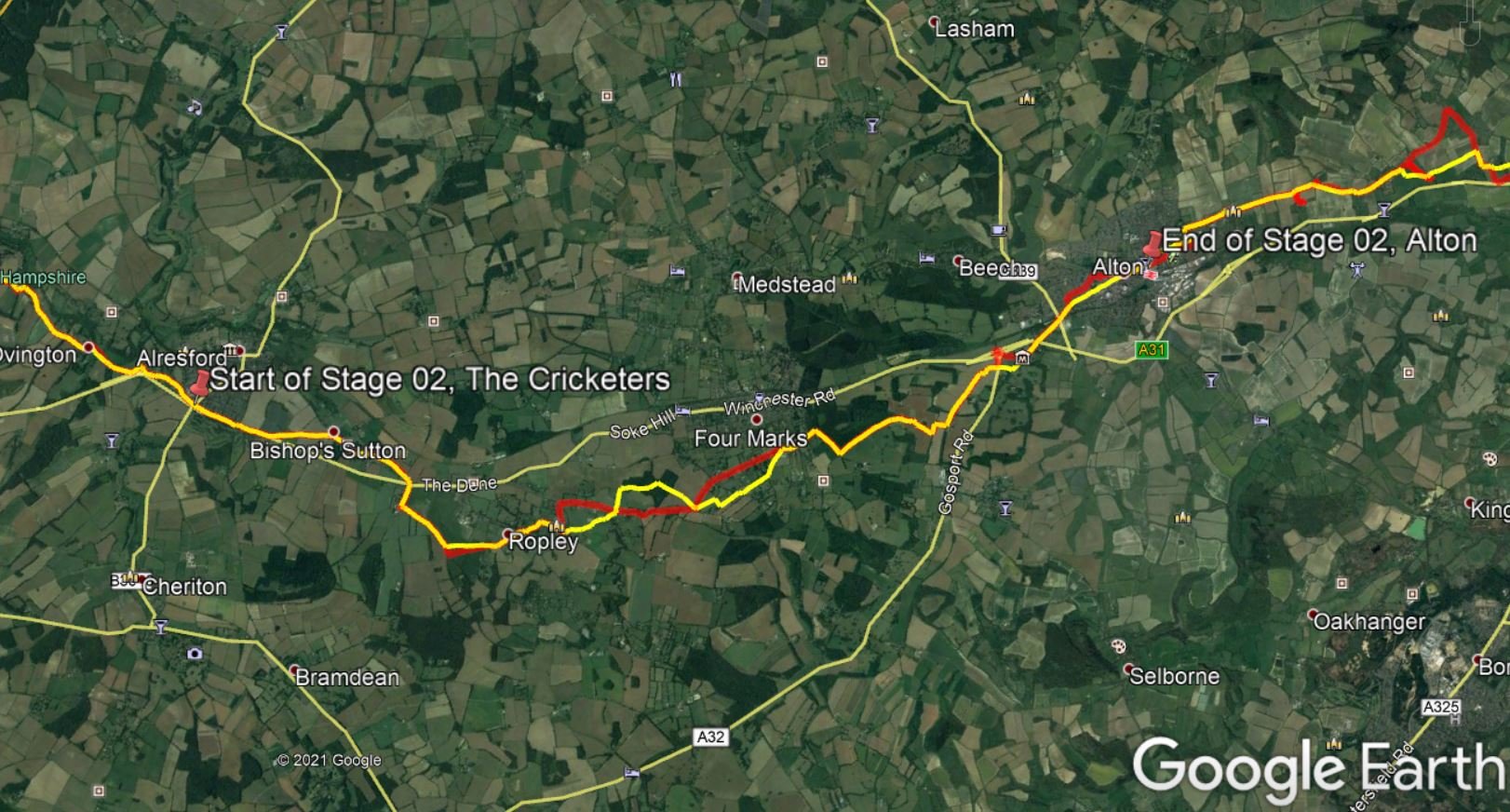
We didn’t stop in Alresford: I would imagine that in normal times the Cricketers pub would be a good refreshment / toilet stop for pilgrims – but in our case the pub was closed due to the pandemic.
We continued riding on Tichborne Down Street before taking Whitehill Lane towards Bishop’s Sutton. After Bishop’s Sutton, the route went along the edge of a grassy field (after a rather challenging kissing gate), and this is where I filmed Katy and I talking. As Katy mentions on the video, we should have continued on the B3047 until it crosses the A31 onto Old Park Rd and then Parkside Lane. It was in the middle of Parkside Lane that we entered the corn field you can see in the video and the pictures below towards Ropley Village: it was quite surreal to ride in the middle of a corn corridor!
After Ropley, we had to find an alternative route because it was a footpath (rather than a bridleway) and the kissing gate was too narrow to get through with the bike (you can see the divergence on the map) – and we had to do the same again at the junction with Andrew’s Lane, this time because of a stile (which really wasn’t possible on a bike), diverting to Dunsell’s Lane and then Gascoigne Lane / Gilbert Street.
The same happened at Kitwood Lane (you may by now be sensing a theme…), because the kissing gate was very narrow and there was a clear sign asking people not to cycle on the footpath . The kissing gate in question is on the right of Kitwood Lane and, if you are cycling, I recommend you instead take the left at the fork where Swelling Hill becomes Kitwood Lane. I wish roads in England didn’t change names so often… Kitwood Lane becomes Alton Road at a five-way junction a few hundred metres further on. It’s all quite confusing, I know – but if you are English you’re probably used to it! The walkers’ path joins Alton Road about 1.3 km later, becoming a dirt path with trees on both sides that give the impression of being a green tunnel, which was rather lovely.
Just before the village of Chawton there is another kissing gate – but this one, thankfully, is manageable. After this you’ll be back on the A32. The walkers’ path leads to a set of steps on the other side of the road, which we decided to avoid, riding instead towards the roundabout and taking the Winchester Road exit. This will all lead you to Jane Austen’s house, which is now a museum and the point at which Katy does some talking in the video.
Now we were pretty much in Alton, but we got a bit confused navigating the urban roads – I think because Komoot (the app that I’ve been using) was guiding us through low-traffic roads rather than along the main road taken by the walkers’ path.
The picture gallery below shows the pictures taken by Katy and me as we left Winchester and along this stage. Click on any picture to enlarge.
I hope you enjoy the video and the photos .


Stage 03: From the Alton House Hotel in Alton to the Bishops Table Hotel in Farnham.
If you haven’t done so already, please watch the video first and then read this blog for more detail! I didn’t want to include all this information in the video voiceover because it would have added too much to the length of the video (which is 9’06”).
The picture below was used in the video and I hope will help you make more sense of the text below.

As before, we didn’t stop in Alton as by this point it was already 17:15 and we were feeling the pressure of not wanting to arrive in Farnham in the dark. The walkers’ route seemed to want us to cross Alton Rugby Football Club but, looking at the grassy field, we decided not to cycle over it; thankfully it was easy to find the path on the other side of the pitch. This then took us past the Church of Holy Rood in the village of Holybourne where, in spite of being pressed for time, I couldn’t resist stopping and taking a picture (unfortunately the church itself was closed, as was so much in 2020). Further on, the path took us to some fields, one of which we would have chosen not to ride on, were we not so pressed for time: the soil had been prepared for planting and it was all uneven and, although the footpath is very clearly marked on the map going straight across (which of course we did), there was no obvious track on the ground. We consulted maps at the time and no sensible alternative appeared to be available without considerable back-tracking – but later, on closer inspection using Google Earth, there appears to be a forest track that leads to a dirt farm road. (I don’t actually know if that dirt road is open to the public, but anything would be preferable to crossing that field!) This dirt road would meet the walkers’ path just before the village of Upper Froyle, less than a kilometre away.
After Upper Froyle, trying to keep on the walkers’ path, we turned right onto Gid Lane, to find ourselves at a narrow kissing gate that also led to a farm field. Gid Lane ends at the A31, which is a very busy main road and we weren’t keen to ride on it – so we backtracked and continued in the direction of Lower Froyle, turning right towards the Anchor Inn pub and getting on a parallel road to the A31. I couldn’t find the name of this road, because strangely no roads in that area are named in Google Maps / Earth.
We made one last attempt to rejoin the walkers’ path by going up Pax Hill (you’ll see the photo of a white bike at the top of the hill), but that led to yet another narrow kissing gate, which wasn’t possible with bikes. So it was backtracking again for us, and we continued on the road parallel to the A31.
Arriving at the village of Bentley, we turned left onto Hole Lane, leaving the paved lane at a single track through some woods where I took pictures of wild pheasants that crossed our path. We had to climb a hill through a field of dried-out wheat stalks and the sunset at the point was quite spectacular – I should have stopped to take a picture, but you’ll get a glimpse of it in the video.
Then we were back on paved lanes, and passed a big solar farm on the right. At this point, Katy and I got separated for a few minutes, as she was a bit behind and our navigation systems were showing different routes so, after a quick phone call, I backtracked a few hundred metres and met her again on a single track heading towards Dippenhall. At this point we could have taken Crondall Lane for a more direct paved route to Farnham, but we decided to stick to the walkers’ path that took us along some nice dirt tracks up to Middle Old Park and Park Ln, arriving at Castle Hill right in front of Farnham Castle.
We arrived at the Bishops Table Hotel in Farnham much later than we expected, at around 19:45, just as dusk fell – but although the light was fading, it was still clear enough for my filming to be OK (this wasn’t the case in many of the following days of the pilgrimage, when it got dark before I finished riding!). We were tired, but very happy to have arrived and rewarded ourselves with some excellent dinner that night.
The picture gallery below shows the pictures taken by Katy and me as we left Winchester and along this stage. Click on any picture to enlarge.
I hope you enjoy the video and the photos.


<- Previous Post (Intro) | Next Post (Day 2) ->
If you have any questions, don’t hesitate to comment or send me a message through the contact form.
Please subscribe to my Blog and/or to my YouTube channel if you don’t want to miss the next one and help me spread the word by liking and sharing my Facebook Page, Instagram and Tweeter feed also.
Thank you for your time!
Do you like these posts? Why, then, don’t you pay me a coffee to help with the blog hosting cost and as a caffeine incentive to keep me going through the long hours of the night? (Suggested amount: £2.00 or USD $3.00 or 2.50€ or whatever you want to give).
You may donate through my Patreon Page or through PayPal directly.
![]()