Category Archives: Faith’s Way

http://eyecycled.com/2018/02/28/faiths-way-caminho-da-fe-introduction-day-zero/

Faith's Way (Caminho da Fé), Day 4: From Casa Branca to Vargem Grande do Sul (D. Cidinha)

In this post…

    1. Introduction
    2. Measures and expenses for this day (Garmin Telemetry)
    3. Stage 07: From  Casa Branca to Itobi + Video
    4. Stage 08 (+ 1/2 of 9): From Itobi to Vargem Grande do Sul (Dona Cidinha’s Hostel) + Video
    5. Pictures taken on this day.

Introduction

If this is the first post you read on this series, I recommend you take a look at the introduction post published on the 28th of February 2018. That post explains what the Faith’s Way is, my reasons for doing it and provides information that might be useful to you, if you decide you want to do it too.

In this post I will cover the 4th day of this 12 day / 600 Km journey between the town of Casa Branca and the rural hostel of Dona Cidinha (Dona translates to Mrs. in Portuguese, hence Mrs. Cidinha) via the town of Vargem Grande do Sul, all in the federal state of São Paulo.

As explained in the introduction post, based on the experience I had when creating videos for the Camino de Santiago in 2015, when I started this series my intention was to divide the distance between the major towns or urban centres as separate stages, otherwise the videos would become too long to watch. It turns out, however, that many pilgrims prefer to overnight away from urban areas in one of the many rural hostels along the caminho.

So, if I was to follow this rule, stage 7 would be between Casa Branca and Itobi, stage 8 between Itobi and Vargem Grande do Sul and stage 9 between Vargem Grande do Sul and the village of São Roque da Fartura, however as I stopped in Dona Cidinha’s hostel that night, half of stage 9 is covered here and the other half will be covered in the next post.

You can download the official map of the Caminho from the website of the Friends of the Caminho Association. From there you can also download a list of credentialed accommodations for your journey. Most places in that list are simple family owned pilgrims’ hostels. Some in very rural locations (farms) others in more urban areas. Some establishments are hotels. Family owned Pilgrims’ hostels along the way have usually a set value that includes the meals as well, typically dinner and breakfast, but all hotels listed there will also offer a reduced pilgrim’s rate provided you present them your pilgrim’s credentials.

Back to Top

Measures and expenses for this day (Garmin Telemetry)

    • Distance traveled from Casa Branca to Dona Cidinha’s Rural Hostel : 59.73 Km
    • Total duration of this journey: 7h 6min
    • Total moving time: 4h 39m
    • Overnight location at the end of the journey:
      • Dona Cidinha’s Rural Hostel (they do not speak English), +55 19 9 81700069
    • Total expenses on this day: R$ 99.00
      • Food: R$ 29.00 (Burger in Itobi)
      • Accommodation: R$ 70.00 (Includes Dinner and Breakfast)
  • Total Elevation Gain on this track: 880m
  • Average Speed: 8.0 Km/h
  • Average Moving Speed: 12.2 Km/h
  • Max Speed achieved: 61.6 Km/h
  • Average Heart Rate: 124 bpm
  • Max. Heart Rate: 160 bpm
  • Calories burned: 2,556 CAL
  • Click here to see the Garmin Connect page for this activity
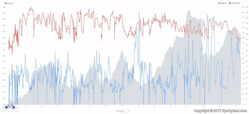
CF04, Garmin Stats
Elevation, Speed and Heart Rate between Casa Branca and Dona Cidinha’s Rural Hostel on the day 4 of my Pilgrimage.

Back to Top

Stage 07: From  Casa Branca to Itobi + Video.

Pilgrims who want to experience the “true” pilgrimage experience (if there is such a thing) have to accept that pilgrims’ hostel are often a difficult place to sleep. Some people have trouble sharing a room with just one person more, imagine several. As described in the previous post, The pilgrim’s hostel  of the Catholic Church of our lady of the exile in Casa Branca has 2 large bedrooms. The one I stayed in has a little common area with a sofa, a TV and a dinning table and the room itself with 3 beds and a bathroom / toilet, which is a bit of a luxury. I don’t mind sharing, but there is nothing like having a room just for oneself. No worries about noises from people snoring (one’s one or others) and those that have to go the the toilet in the middle of the night. As I was fortunate to be the only one in the room that night, I slept very well. Bed was comfy and the temperature was perfect.

The next morning breakfast was served in the hall and was very simple. Consisted of bread, butter, different types of jam and some fruit. Coffee and milk were also available. This was the moment I stamped my pilgrim’s credentials and also signed the guest book (they leave the stamp and the book on the breakfast table). I did not meet the pilgrim ladies from the day before, but I met Andrea, who was setting up the breakfast table.

After breakfast I packed the bike and left, making the mistake of taking the room key with me. I had put the key in the back pocket of my shirt to return it to Andrea in the breakfast room, but in the hurry to leave (as it was already a bit late by that time), I forgot to do it.

I rode to the town centre of Casa Branca and visited the cathedral. The cathedral is quite impressive for the size of the town. I spend quite some time there taking pictures and appreciating the paintings in the walls and ceiling. It was at that moment I realised I still had the room key with me, so I phoned Andrea at the hostel who told me to leave it at the cathedral and someone would pick it up later. It was a relief not having to cycle back the distance from the cathedral to the hostel.

The GPS data tracked by my Garmin shows that I rode 15.61 Km between Casa Branca and Itobi, which is consistent with the distance shown in the official map of the Caminho. I did this in 1h 59m by bike, but this includes the stop at the cathedral.

I’m not going to describe the journey to Itobi as you can watch it on the video above, but as highlights I can mentioned the small forest fire that the town’s public service was putting off on the outskirts of Casa Branca and the fact that when I arrived in Itobi, I followed the yellow arrows that led me away from town. Although the same thing happened in Cravinhos on the 1st day of the pilgrimage I was still under the impression that the arrows would always take you first to the town centre or to the nearest pilgrim accommodation, but that doesn’t appear to be the case. I rode about 3.5 Km and then turned back to the town centre, a 7 Km waste of time and effort, but that is part of a pilgrimage. At least I had the opportunity to have a really nice burger in Itobi after stamping my pilgrim’s credentials at the Ypê Hotel, the only credentialed pilgrims’ accommodation in the accommodation list of the friends of the caminho association.

Back to Top

Stage 08 (+ 1/2 of 9): From Itobi to Vargem Grande do Sul (Dona Cidinha’s Hostel) + Video

OK, as explained in the above introduction, the next stage should cover only the distance between the towns of Itobi and Vargem Grande do Sul, however, as I arrived at the Prince Hotel (Hotel Principe) in Vargem Grande do Sul, it was still early in the day for me, so I decided to cycle the further 15 Km to Mrs Cidinha’s hostel, which I had heard good things about before leaving to do the caminho. This is the reason why this video is a little longer than usual and why stage 9 will be broken in two. So let’s call this the stage 8 plus 1/2 of stage 9, shall we? The next half of stage 9 between the rural hostel of Dona Cidinha and the village of São Roque da Fartura, will be covered in the next post.

If you are just covering the distance between Itobi and Vargem Grande do Sul (stage 8), the Prince Hotel is one of the credentialed places for pilgrim accommodation in town. The hotel is practically inside the grounds of a petrol station, so it might be a little difficult to find. They will also stamp your pilgrim credentials and offer you a pilgrim rate if you decide to stay there.

The GPS data tracked by my Garmin shows that I rode 18 Km between Itobi and Vargem Grande do Sul, which for some reason is 3 Km more than indicated in the official map of the Caminho. After Vargem Grande do Sul I also rode a further 15.37 Km to the rural hostel I slept that night. It took me 1h 31m to cover this distance and a further 2h 36m to cover the distance between Vargem Grande do Sul and Mrs Cidinha’s rural hostel.

The journey between Itobi and Vargem Grande do Sul was largely uneventful, with exception to the fact that as I arrived in Vargem Grande the battery of my GoPRO ran out, hence the reason why there is a tiny portion of urban cycling missing from the footage, but nothing that matters. For walking pilgrims, please beware that about 13 Km of this route is along side the Father Gino Righetti road, which is paved and has moderate traffic. I did follow the yellow arrows, but unless I missed one, the distance tracked by my Garmin was 18 Km, which for some reason is 3 Km more than the distance shown in the official map of the caminho.

After stamping my pilgrim’s credential at the hotel, I rode into the town centre and did a quick stop for a picture at the town’s main church and continued the journey. As in any activity, distraction comes at a price. I somehow missed a pair of yellow signs painted at the lamp post indicating a right turn at the next crossing and that has also costed me an extra 2 Km of cycling. Thankfully I realised I was wrong early enough. After I watched the footage I came to the conclusion that the signs where indeed a little hard to see, so I have pointed them up at the video to avoid any other pilgrims making the same mistake.

In the outskirts of town there is a crossing over a dangerous highway. The arrows appear to invite the pilgrim to jump over the concrete barrier in the middle of the road, but please do NOT do that. Turn left towards the round-about at the bottom of the road (just about 250 m away) and use the round-about to cross to the other side. As I write this post a few years after being there, I am reliably informed that the route has changed slightly and that the yellow arrows now guide the pilgrims directly to the round about, but decided to leave this warning just in case.

The journey to Dona Cidinha’s hostel was the toughest part of the day. The small sand and dust filled dirt roads (at times), had hills that forced me to push my bike several times. That should explain the reason why I covered the 18 Km between Itobi and Vargem Grande do Sul in 1h 31m, but the 15.37 Km from Vargem Grande do Sul to Dona Cidinha’s rural hostel in 2h 36m.

I arrived at the rural hostel as the sun was setting on the horizon, which was a really nice way to end the day. The hostel is in a hill and the views from there are great. Dona Cidinha and Mr Francisco were already expecting me as I had phoned ahead. Again I was fortunate (?) to be the only pilgrim in the hostel that night, so I had the entire house for me (the hostel is a in separate building from the house of the hosts). Mr Francisco brought the home made dinner for me that night and it was delicious. They are a very nice and gentle couple and I truly recommend that you stayed with them if you don’t mind the fact the the hostel is pretty much in the middle of nowhere and that there is no WiFi there (4G signal was OK though). The hostel is large and in its 4 bedrooms and living room it can accommodate about 20 pilgrims at once. They have a large bathroom / toilet inside the house and a small toilet in the outside barbecue place, where there are also several tables and chairs. The bedroom I stayed had a double and a single bed. The other rooms have a mix of bunk beds and single beds. The living room has a sofa and a TV and also contains a single bed and a bunk bed. The hostel has also a large and fully equipped kitchen with a long table, a fridge, a freezer and a microwave oven.

The guest book contains a few notes in Spanish and English indicating that, despite its remoteness, people from several nationalities visited there. The walls of the hostel are covered with pictures and post cards sent by previous visitors and you can really spend hours looking at all of them if you want.

Back to Top

Pictures taken on this day.

Click on any picture for full detail

The following pictures are photos taken from the Guest Book pages of the pilgrims’ hostel at the Catholic Church of our lady of the exile in Casa Branca, São Paulo, Brazil.

Back to Top

If you have any questions, don’t hesitate to comment or send me a message through the contact form. Please subscribe to my Blog and/or to my YouTube channel if you don’t want to miss the next one and help me spread the word by liking and sharing my Facebook Page and Tweeter feed also. Thank you all for your time and “Bom Caminho!”.


Do you like these posts? Why, then, don’t you pay me a coffee to help with the blog hosting cost and as a caffeine incentive to keep me going through the long hours of the night? (Suggested amount: £2.00 or USD $3.00 or 2.50€ or whatever you want to give). You may donate through my Patreon Page or through PayPal directly. Become a Patron

Please rate this post by clicking on the desired star (1 = Awful, 5 = Excellent)
[Total: 1 Average: 5]

Faith's Way (Caminho da Fé), Day 01: From Sertãozinho to Cravinhos

In this post…

    1. Introduction
    2. Measures and expenses for this day (Garmin Telemetry)
    3. From  Sertãozinho to Dumont + Video
    4. From Dumont to Cravinhos + Video
    5. Pictures taken on this day.

Introduction

If this is the first post you read on this series, I recommend you take a look at the introduction post published on the 28th of February 2018. That post explains what the Faith’s Way is, my reasons for doing it and provides information that might be useful to you, if you decide you want to do it too.

In this post I will cover the 1st day of this 12 day, 600 Km, journey between the town of Sertãozinho, were I started my pilgrimage, and the town of Cravinhos, both in the federal state of São Paulo.

As explained in the introduction post, I broke the entire journey into 21 stages, as per the official map of the Caminho. There will be 1 video for each stage of the journey, so the blog post for this day contains two videos. Once covering the journey between Sertãozinho and Dumont and another between Dumont and Cravinhos.

You can download the official map of the Caminho from the website of the Friends of the Caminho Association. From there you can also download a list of credentialed accommodations for your journey. Most places in that list are simple family owned pilgrims’ hostels. Some in very rural locations (farms) others in more urban areas. Some establishments are hotels. Family owned Pilgrims’ hostels along the way have usually a set value that includes the meals as well, typically dinner and breakfast, but all hotels listed there will also offer a reduced pilgrim’s rate provided you present them your pilgrim’s credentials.

Back to Top

Measures and expenses for this day (Garmin Telemetry)

  • Distance traveled from Sertãozinho to Cravinhos71.54 Km
    • Please read item number 4 in this post, as this includes navigation errors on my part.
  • Total duration of this journey: 8h 25m
  • Overnight location at the end of the journey:
  • Total expenses on this day: R$ 120.90
    • Food: R$ 58.90 (pizza delivered to hotel, managed to eat only 1/2)
    • Accommodation: R$ 62.00 (Breakfast incl)
  • Total Elevation Gain on this track: 1,178m
  • Average Speed: 8.5 Km/h
  • Max Speed achieved: 46.5 Km/h
  • Average Heart Rate: 146 bpm
  • Max. Heart Rate: 180 bpm
  • Calories burned: 4,286 CAL
  • Click here to see the Garmin Connect page for this activity
First day on the Faith's Way
First day on the Faith’s Way

Back to Top

From  Sertãozinho to Dumont + Video.


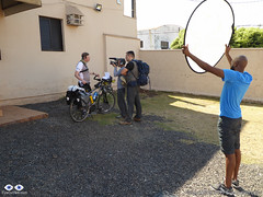
Being interviewed by Glogo TV Network at the hotel's parking lot.As planned the night before I woke up early and went downstairs to have breakfast with the TV crew of Globo TV. They took a lot of shoots of the crew having breakfast and helped me with some pictures. Before leaving we shoot the interview outside at the hotel’s car park, which, for several reasons, such as external noise and mistakes, required many takes. For example, during the interview I mentioned that the recordings were going to be done in Time-lapse format with a GoPRO 4, and the mere mentioned of the brand invalidated the take (advertising).

From everything that was recorded during the interview in that morning, only a tiny portion was actually aired. In my 3 seconds of fame in national television I appear saying the Caminho was mostly done on dirt tracks, hence the reason it was going to be difficult. At first this sounds kind of obvious, but what was missing there was the fact that we were speaking about my previous pilgrimages to Santiago de Compostela and Rome (Via Francigena) and how most of them were on paved roads, so, since the Faith’s Way is mostly on dirt tracks, I considered this pilgrimage would be a lot harder than the previous ones, even though the distance was shorter. That’s OK though. Glad to have had the exposure I did.


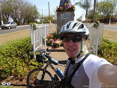
P1090200After the interview the drone operator followed me in their car and did some aerial shoots of me as well as instructed me to do certain things, which otherwise wouldn’t be in my nature to do, such as to raise my arms at the statue of our lady by the town’s gate. Due to these activities I actually left Sertãozinho quite late, at around 10:30am. About 1 Km after the small statue of our lady were the last aerial shot was taken by the drone operator (you’ll see it in the video), I crossed underneath the motorway and took a small road out of town which soon turned into a dirt road.

A guy on a motorbike rode parallel to me for a few meters and the biker asked me questions such as were I was going and if I was alone. I was honestly very reluctant to talk to him as many robbers use this method to steal. Thankfully that wasn’t the case and my ride to the small town of Dumont was uneventful, despite the very thin sand and dust on the roads as it hadn’t rained for over 2 months there.

Almost the entire path is done among sugar cane plantations, so the views aren’t that great, but there are places worth a few pictures along this way.

Back to Top

From Dumont to Cravinhos + Video

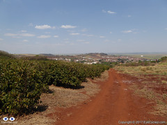
Coffee Plantation on the left and the small town of Dumont in the background

As I arrived in Dumont I stopped for some pictures and to determine were to stamp my pilgrim’s credential. I figured out that the pilgrims’ hostel in the list of accommodations was actually outside of town and moved on.

This hostel is maintained by the Veronezi family in their property outside of town. As I arrived at the Veronezi farm, I turned left and went to the meat shop (Casa Veronezi) were the lose stones at the car park caused me to fall off my bike for the 1st time. It was a really stupid fall due to the fact the front wheel skidded on the lose stones on the ground and my right foot got stuck in the pedal straps. Unfortunately I ended up tearing my Castelli leg warmer in the process, a little piece of cycling wear I was very fond of 🙁

Met with Alvaro at the meat house who directed me to the hostel were I met his mother Ms Helena Veronezi. Alvaro runs the meat house while Mrs Helena takes care of the pilgrims and runs the hostel. Very nice people. Ms Helena stamped my credentials and offered me water and fruit. As I left the Veronezi’s I was told there would be a locked gate by their fish pond, but that I should just ask their daughter to open the gate for me at the bar near the lake, so I did.

Zé Goleiro Bar
Zé Goleiro Bar

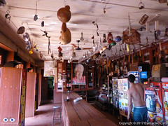
Continuing on dirt tracks among the sugar cane plantations I got to Zé Goleiro bar (José, the Goalkeeper’s bar), an establishment that has been there in the middle of nowhere since 1937 which is now run by Zé Goleiro´s son as Zé Goleiro died in 2009. Very interesting place with a lot of stuff hanging from the ceiling.

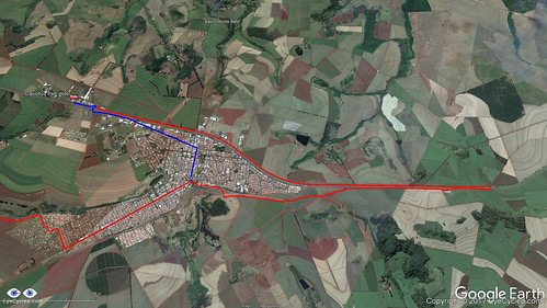
The map of the Caminho indicates the distance between Dumont and Cravinhos is of 37 Km, but the map doesn’t indicate the point in Cravinhos where those 37 Km end. The two establishments listed in the accommodation guide for Cravinhos are somewhat on the outskirts of the town, especially the one I decided to spend the night in, the Cravinhos Park Hotel, which out of the two appeared to be the better one and did accept credits cards also (although not highlighted in the guide).

As I got to Cravinhos, I made the mistake of assuming the yellow arrows would lead me to these establishments. Unless I’ve missed an arrow somewhere, they didn’t seem to. I honestly only saw yellow arrows pointing in the direction I went.

Red line is the path I took. Blue line is the path I should have taken.

Unfortunately, as stubborn as I am, I continued blindly following the arrows out of town, only stopping at a petrol station some 7 to 8 Km out of town to ask for directions. To be honest, there wasn’t anyone available to ask for directions outside of town anyway, but I should have turned back earlier.

Once the staff at the petrol station told me how far back I would have to ride to get to the hotel I was faced with the decision of going back or moving forward. I decided to go back because it was already getting dark and according to the map the nearest town was 31 Km away, perhaps a little nearer since I had already done about 7 Km out of town, so I decided to go back. This led me to ride an additional 18.69 Km, in other words, I rode 55.69 Km in total between Dumont and Cravinhos that day. So take notice of that, if you plan to start your pilgrimage from Sertãozinho as I did.

I have arrived at the hotel in the dark of night, which wasn’t cool, but it all belongs to the adventure. In a pilgrimage you should always expect the unexpected.

Back to Top

Pictures taken on this day.

Click on any picture for full detail

Back to Top

If you have any questions, don’t hesitate to comment or send me a message through the contact form. Please subscribe to my Blog and/or to my YouTube channel if you don’t want to miss the next one and help me spread the word by liking and sharing my Facebook Page and Tweeter feed also.

Thank you all for your time and “Bom Caminho!”.


Do you like these posts? Why, then, don’t you pay me a coffee to help with the blog hosting cost and as a caffeine incentive to keep me going through the long hours of the night? (Suggested amount: £2.00 or USD $3.00 or 2.50€ or whatever you want to give).
You may donate through my Patreon Page or through PayPal directly.

Become a Patron

Please rate this post by clicking on the desired star (1 = Awful, 5 = Excellent)
[Total: 4 Average: 5]

The "Faith's Way" (Caminho da Fé).

Logo of Caminho da Fé

Dear EyeCycled friends,

it gives me great pleasure to announce to you all that next week I will start my 3rd Christian Pilgrimage by bike. It’s called “Caminho da Fé” which literally translated to English means “The Faith’s way”, but it is also sometimes translated as “The walk of faith”.  This pilgrimage route is now considered to be the Brazilian equivalent of  the way of St. James or Camino de Santiago, which I’ve done in 2015.

There is extensive material about the “Caminho da Fé” on the Internet, but in Portuguese only.  I could not find much in English, so the English version of this post will be more detailed than it’s Portuguese one, so to give you guys more background information of what the pilgrimage is all about (most links on these page will open to English Language resources though).

Brazilians have been walking to the Basilica of the National Shrine of Our Lady of Aparecida for generations. Many to fulfil religious promises (i.e. to obtain a cure for some illness or for other types of graces), others for cheer devotion. With 18,000 m2  (190,000 sq ft), the basilica is the 2nd largest catholic church in the world losing only to St. Peter’s Basilica in Vatican City.

Map of the
Map of the “Caminho da Fé” (click to open. Source AACF)

In 2003 a group of pilgrims who had walked to Santiago de Compostela a couple of times decided to create a pilgrimage route between Aguas da Prata in the Federal State of São Paulo and the Basilica, in Aparecida do Norte, 318 Km away on the designed route (walking paths). Currently, however, the route has many, so called, “branches” all of them starting from different cities, but passing through Aguas da Prata, on the original route designed in 2003. These, in turn, have also a few options which may increase or decrease the distance between the starting point and Aparecida do Norte. The branches are as follows:

#BranchDistance in Km
Option 1: Via the town of Pindamonhangaba
Distance in Km
Option 2: Via the town of Guaratinguetá
1Aguaí to Aparecida364341
2Aguas da Prata to Aparecida318295
3Caconde to Aparecida390367
4Mococa to Aparecida408385
5São Carlos to Aparecida536513
6Sertãozinho to Aparecida571548
7Tambaú to Aparecida424401

Source: AACF (Friends of the “Caminho” Association. Site in Portuguese only)

I’ve chosen the longest path, starting from Sertãozinho, not necessarily because I want to ride more (although this was one of the reasons), but because of logistics. There is a direct bus from my current whereabouts to Ribeirão Preto, a city only 20 Km from Sertãozinho, so I only need take 1 bus journey (of 12 h though) to get to my starting point.

My entire journey will start on the early hours of Sunday, the 18th of September, with the bus to Ribeirão Preto. From Ribeirão Preto to Sertãozinho there is a short distance of just over 20 Km, perfectly doable by bicycle, but I’ve been advised to avoid this track because it goes through some high crime areas between the 2 towns (in Brazil, unfortunately, this is a constant worry).

So, as I arrive in Ribeirão Preto I may take yet another bus journey, a short one though, to Sertãozinho, or, if I am feeling adventurous, ride my bike (generally speaking armed thieves steal the entire bike with everything on it, and on the rider… it would be a shame if my pilgrimage was to end before it could even begin though).

In Sertãozinho I will overnight in the Agapito Hotel, one of the few places where you can buy the pilgrim’s credentials, which, exactly like in the Way of Saint James, you will need to stamp along the way in order to obtain the certificate of completion as you arrive in the Basilica in Aparecida do Norte.

Typical
Typical “Caminho da Fé” Pilgrim’s Credentials (extrenal link. Click to open it on source site)

From Sertãozinho I’ll let faith take me (no pun intended). I was going to purchase the excellent “Caminho da Fé” guide (link in Portuguese only) from Antonio Olinto, but I didn’t get to do it, so I will simply follow the yellow arrows (another thing copied from the the way of St. James / Camino de Santiago).

My two previous pilgrimages experiences taught me a lot and minimised a number of fears I had before I started. This one, in Brazil, is a bit different than the previous two as it introduces the fear of being victim to the social / economic situation of the country. Not that being a victim of crime isn’t a possibility during the Camino de Santiago where even murders of pilgrims are know to happen, but it is a question of the likehood of it happening, which in Brazil is much higher than in countries of the European Union.

The good thing about starting my pilgrimage on the 19th of September, though, is that I apparently will not be doing it alone, as I originally thought I would. I found out today that a crew of the Brazilian TV network “Globo” will be recording a program about the “Caminho da Fé” and that the main reporter, who I had the pleasure of talking to on the phone today, will also be riding on a bike all the way to Aparecida, supposedly followed by his TV crew. Who knows, I might even appear on the telly, which is an unexpected surprise. Life does have a way to surprise you, if you give it a chance.

As usual, I will try to post as much as I can along the way, but experience has thought me that any posts are more likely to happen on the EyeCycled Facebook page than on the blog. So, please, if you have not done so yet, and would like to follow me on this little adventure, make sure you like the page.

If you’ve seen my previous post, you’ll be aware that I recently lost a “non-human” friend, my trusted Dell XPS 15 notebook, which I used to edit the videos for the YouTube channel and create content for the blog. As with previous pilgrimages, I fully intent to cover the entire route of the “Caminho da Fé” with time-lapsed videos and bring as much info and media to you as possible. Without a proper computer that might take awhile though, but don’t give up on me. Like “Arnie”, I’ll be back!

“Buen Camino!” or in this case “Bom Caminho!”

PS. If you can read in Portuguese, the site of the AACF (Friends of the “Caminho” Association) is an excellent source of information.

(more…)

Please rate this post by clicking on the desired star (1 = Awful, 5 = Excellent)
[Total: 4 Average: 5]