Tag Archives: Tergnier

Via Francigena, Day 6/29: From Reims to Châlons-en-Champagne


"I like to walk at my ease, and stop when I like. A wandering life is what I want. To walk through a beautiful country in fine weather, without being obliged to hurry, with a pleasant prospect at the end, is of all kinds of life, the one best suited to my taste.", Rousseau.

In this post…

  1. Introduction
  2. The statistics and metrics of the day
  3. The most memorable occurrences, moments and thoughts
  4. Video of Lightfoot Guide Stage 21, from Reims to Verzenay
  5. Video of Lightfoot Guide Stage 22, from Verzenay to Condé-sur-Marne
  6. Video of Lightfoot Guide Stage 23, from Condé-sur-Marne to Châlons-en-Champagne.
  7. Pictures of the day.

Introduction

Blog post about the 6th and 7th day published during the journey on the 23rd August 2016

This post complements the post I published on the 23rd of August 2016 in which I described the experiences I had on the 4th of August 2016 while riding between Reims and Châlons-en-Champagne in France. I am not going to repeat the content of that post in this one again, but I will try to add a few highlights for each one of the stages below. I encourage you to read the previous post before continuing on this one.

Back to Top

Statistics and metrics of the day

Back to Top

Most memorable occurrences, moments and thoughts:
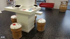
Champagne cork seats in Reims' Tourist Information Office
Champagne cork seats in Reims’ Tourist Information Office

As I mentioned on the earlier post, I left Reims quite late because I walked to a nearby MacDonalds to have breakfast and to the Tourism Information Office to get my pilgrim’s credential stamped. On the way back I decided to go have a chat with a couple that was sitting with their bikes on a café and, confirming my suspicions they were also Francigena Pilgrims who started in Canterbury and were heading to Rome by bike.
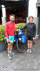
Giovanni and wife were also cycling from Canterbury to Rome

The gentleman’s name was Giovanni. Unfortunately  I forgot to write their names down and don’t remember the name of his wife anymore.  I believe she was German, but I could be mistaken. They were, at that time, the first cycling pilgrims I had seen on the journey, so I was very happy to meet them, even though I thought it was going to be the last time I see them as they were following a different route. They were riding Mountain Bikes and decided for a rougher track. I was, however, wrong. As I arrived in Châlons-en-Champagne at the end of the day, guess who I met at the Tourism Information Office? Exactly! Small world. We then got our pilgrims’ credentials stamped and the address of the local youth hostel and decided to spend the night there.
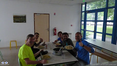
Myself in Yellow, David at my side. On the other side of the table, Fabio in blue and Giovanni and wife.

The Youth Hostel in Châlons-en-Champagne is very good. Typical hostel with rooms containing several bunk beds, but every thing was clean and tidy. There we meet other pilgrims and travelers, like David from Belgium, who wanted to walk all the way to Santiago de Compostela, and Fabio who was just cycling from Holland, were he lived with family, to his home town  of Brindisi in Italy. Fabio had already bought some food on the local market and invited us all for dinner. A delicious pasta, that he cooked in the Youth Hostel’s guest kitchen.

After dinner we all went out for a walk around town and for some beers. It was a great evening in the company of some really nice people.

The journey from Reims to Châlons-en-Champagne was really beautiful, despite the rain and the risk of falling due to the slippery tyre grooves on the ground of the canal towpath.

Champagne Vineyards on the way to Verzenay.

On the way to Verzenay I rode among the vineyards of champagne produces like Moet et Chandon, one of the most recognisable (and expensive) brands of Champagne. If was like being in the middle of a sea of grapes. I was tempted to eat a few off the trees, but they appeared to be too green. As in Verzenay, everything in Condé-sur-Marne was closed, so I couldn’t find any place to stamp my pilgrim’s credentials.
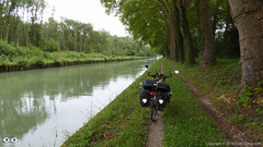
Those tyre grooves where my bike is standing were at times quite deep and with the rain quite muddy and slippery. Really beautiful ride though.
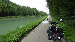
Felt almost like I was riding on a "Cycling Autobahn". Very smooth surface.
Felt almost like I was riding on a “Cycling Autobahn”. Very smooth surface.

From Condé-sur-Marne to Châlons-en-Champagne was entirely done on canal towpaths as my bike was also heavy in the front (I had 2x 10 Kg panniers in the front) it wasn’t easy to steer quickly at times and the grooves were wet and narrow and had quite a bit of mud in them. The townpath eventually became a concrete paved cycle lane and I felt like I was riding on a “Cycling Autobahn”. It was one of the best cycle lanes I rode in life, completely smooth.

Although I covered less than 54 Km this day and despite the rain I had a great time cycling this track and would recommend it to everyone, pilgrim or not.

Please take a look at my picture album (down below) for this day in Flickr.

Back to Top

Video of Lightfoot Guide Stage 21, from Reims to Verzenay

Video Length: 4 min and 19 sec

Back to Top

Video of Lightfoot Guide Stage 22, From Verzenay to Condé-sur-Marne.

Video Length: 4 min 36 sec

Back to Top

Video of Lightfoot Guide Stage 23, From Condé-sur-Marne to Châlons-en-Champagne

Video Length: 5 min 10 sec

Back to Top

Pictures of the day.

Click on any picture for full detail

Back to Top

If you have any questions, don’t hesitate to comment or send me a message through the contact form.
Please subscribe to my Blog and/or to my YouTube channel if you don’t want to miss the next one and help me spread the word by liking and sharing my Facebook Page and Tweeter feed also.
Thank you for your time!


Do you like these posts? Why, then, don’t you pay me a coffee to help with the blog hosting cost and as a caffeine incentive to keep me going through the long hours of the night? (Suggested amount: £2.00 or USD $3.00 or 2.50€ or whatever you want to give).
You may donate through my Patreon Page or through PayPal directly.

Become a Patron


Please rate this post by clicking on the desired star (1 = Awful, 5 = Excellent)
[Total: 4 Average: 4.3]

Via Francigena, Day 5/29: From Tergnier (Auberge de Villequier) to Reims


Private File - Access Forbidden

"A journey becomes a pilgrimage as we discover, day by day, that the distance traveled is less important than the experience gained.", Ernest Kurtz

In this post…

  1. Introduction
  2. The statistics and metrics of the day
  3. The most memorable occurrences, moments and thoughts
  4. Video of Lightfoot Guide Stage 17, from Tergnier (Auberge de  Villequier) to Laon
  5. Video of Lightfoot Guide Stage 18, from Laon to Corbeny
  6. Video of Lightfoot Guide Stages 19 and 20, from Corbeny to Reims
  7. Video footage recorded during a short walk in Reims’ City Centre
  8. Pictures of the day.

Introduction

Post about the 4th (and 5th) day of journey, published on 10th August 2016This post complements the post I published on the 10th of August 2016 in which I described the experiences I had on the 3rd of August 2016 while riding between Tergnier and Reims, including the additional (and unnecessary, might I add) ride from the Auberge de Villequier, where I spent the night before, back to Tergnier . I am not going to repeat the content of that post in this one again, but I will try to add a few highlights for each one of the stages below. I encourage you to read the previous post before continuing on this one.

Back to Top

Statistics and metrics of the day

  • Date: Wednesday, 3rd of August 2016
  • Route: From Tergnier (incl. an additional, and unnecessary 7.41 Km to the Auberge de Villequier where I spent the night) to Reims.
  • Distance: 89.65 Km
  • Departure time from Tergnier: Around 9:05h.
  • Arrival at Reims: Around 18:15h
  • Duration of day’s Journey: 9h 11min
  • Expenses this day: Total = € 54.50
  • Overnight Location: Hotel Le Monopole, +33 3 26 47 10 33
  • Type of Accommodation: Hotel
  • Lightfoot Guide Stages:
  • Physical and Body Stats: Link to the Garmin Connect Page for this ride
    • Duration: 9h 11min
    • Moving time: 5h 33min
    • Average Speed: 9.8 Km/h
    • Average Moving Speed:  16.1 Km/h
    • Max. Speed: 57.5 Km/h
    • Total Elevation Gain: 625 m
    • Average Heart Rate: 125 bpm
    • Max. Heart Rate: 164 bpm
    • Calories: 3,048 CAL
    • Number of Pedal Strokes (Cadence sensor): 17,747

Back to Top

Most memorable occurrences, moments and thoughts:

  • Starting a bike ride under heavy rain is always a challenge for me. Yet, I don’t mind if it starts to rain in the middle of the ride. Go figure!
  • The extra 15 or so Kilometres I rode to and from the Village of Villequier (Auberge where I stayed that night) should be deducted from the total distance to Rome. It was an unnecessary detour
  • The translation of the word “Auberge” (hostel) has different meanings in different languages. In Spanish (Albergue) those are the most common pilgrim accommodations along the Camino de Santiago. In French they are similar to a hotel. In Portuguese (Brazil) they are usually understood as being a shelter house for the homeless.
  • Be prepared to push your bike up to the cathedral / town centre in Laon. Very steep inclines.
  • Laon’s Tourist Information office is conveniently located right besides the cathedral. You can get your pilgrim’s credentials stamped there.
  • 20160803_155420When leaving Laon, if using Google Maps to navigate, beware the App will lead you to a footpath which has very narrow restriction bars at the end. Thankfully, even with all the panniers and load on the bike, I’ve managed to get passed them by raising the bike vertically, but it wasn’t easy.
  • During a water rest at the church in  Corbeny I looked at the guide and decided to skip Hermonville and ride straight to Reims. I wanted to stay in Reims and didn’t want to arrive too late there, so I could have a chance to walk around to city to get to know it a little. I think it was a wise decision, but that was, I believe, the last time I decided to skip a stage in the guide. It wouldn’t have taken me much longer to ride to Hermonville and from there to Reims.
  • The road to Reims was quite busy and no hard shoulder to ride on. Although I did not feel unsafe, I would advise caution. I am inclined to believe the Lightfoot recommended route is probably a better option in terms of vehicle traffic.
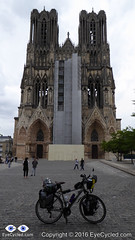
  • P1010430Reims is a city worth spending time. The cathedral is pretty amazing, even with all the scaffolding at the time. The city centre is lively with lots of things to see. The opera house (which I called a theater in the video) has some pretty interesting colour changing lighting in addition to being a very interesting building. Reims is also the French capital of Champagne and you will find references to it in many places like in the tourist information office. You can book visitations and Champagne tasting tours to many of the local producing houses. According to Wikipedia, Champagne ages in the many caves and tunnels under Reims, which form a sort of maze below the city. Carved from chalk, some of these passages date back to Roman times. The a look at the footage I recorded during my short walk around the city centre.

Back to Top

Video of Lightfoot Guide Stage 17, from Tergnier (Auberge de Villequier) to Laon

Video Length: 8 min and 40 sec
To skip introductions and recommendations jump to time stamp 0:35 in the video timeline.

Back to Top

Video of Lightfoot Guide Stage 18, From Laon to Corbeny

Video Length: 5 min 29 sec

Back to Top

Video of Lightfoot Guide Stages 19 and 20, From Corbeny to Reims

Video Length: 6 min 55 sec

Back to Top

Video footage recorded during a short walk in Reims’ City Centre

Video Length: 4 min 15 sec

Back to Top

Pictures of the day.

Click on any picture for full detail

Back to Top

If you have any questions, don’t hesitate to comment or send me a message through the contact form.
Please subscribe to my Blog and/or to my YouTube channel if you don’t want to miss the next one and help me spread the word by liking and sharing my Facebook Page and Tweeter feed also.
Thank you for your time!
(more…)

Please rate this post by clicking on the desired star (1 = Awful, 5 = Excellent)
[Total: 2 Average: 5]

Via Francigena, Day 4/29: From Péronne to Tergnier (Auberge de Villequier)

"Faith is being sure of what we hope for and certain of what we do not see." Hebrews 11:1

In this post…

  1. Introduction
  2. The statistics and metrics of the day
  3. The most memorable occurrences, moments and thoughts
  4. Video of Lightfoot Guide Stage 15, from Péronne to Trefcon
  5. Video of Lightfoot Guide Stage 16, from Trefcon to Tergnier (and further to the Auberge de Villequier)
  6. Pictures of the day.

Introduction

Post about the 4th (and 5th) day of journey, published on 10th August 2016

This post complements the post I published on the 10th of August 2016 in which I described the experiences I had while riding between Péronne and Tergnier, including the additional (and unnecessary, might I add) ride from Tergnier to the Auberge de Villequier, where I spent the night. I am not going to repeat the contents of that post in this one again, but I will add a few highlights for each stage below. I encourage you to read the previous before continuing on this one.

Back to Top

Statistics and metrics of the day

Back to Top

Most memorable occurrences, moments and thoughts:

  • To go or not to go? Woke up many times during the night to the sound of heavy rain. In the early morning I decided to wait in the tent to see if the rain would stop. It meant that by the time I was done with breakfast and packing it was past 11am in the morning, but I think it proved to be the right decision this time (aided by some weather forecast on the phone). Wasn’t really looking forward to packing my gear under rain. The rain resumed just after I left, so I guess I can consider it a lucky dry window, just long enough for me to pack my gear.
  • Château de Péronne
    Château de Péronne

    After leaving the Camping Site the first stop was at Péronne’s tourism information office in the town centre to collect a stamp on my Pilgrim’s Credential. As I was late I couldn’t really explore the town. As with many other towns and villages I’ve been through, Péronne looked like it would have been worth at least a few hours, if I had time to spare.

  • Again and again, Google Maps is good, especially to those like me that are “navigation challenged”. One problem for cyclists is that it tries, as much as it can, to guide the cyclists away from heavy vehicle traffic. Yes, this is good, but it also means it guides you to paths that during or after heavy rain might be very challenging to transpose. As I left Pèronne Google Maps instructed me to leave the “D” road I was to some dirt paths that were very muddy, only to guide me back to the same “D” road about 1.5 Km later. When you don’t know the way, the decision is not always easy. Overall Google Maps helped me more than it hindered me though.
  • The ride to Trefcon was uneventful and the village itself is tiny and it appeared to be completely deserted.
  • It rained basically all day that day (on and off) and after leaving Trefcon the route was mostly on good roads up to the town of Montescourt-Lizerolles, where Google Maps instructed to take a path alongside the railway. The terrain was somewhat challenging as the Swalbe Marathon tyres I have in the bike are not really suited for them. After overcoming the path, I decided not to follow the route Google had planned and take my chances on the major “D” road, the D1, that took me straight to Tergnier. The traffic was intense and the road had guard-rails and no hard-shoulder. I don’t recommend this route, but on hindsight I believe it was the right decision, albeit somewhat riskier than to stick (no pun intended) to the dirt paths.
  • Riding under constant rain is not really fun, but the main challenge, besides the muddy paths, was the strong wind which slowed me down considerably and took away the high visibility orange flag I had in th back of the bike. I arrived in Tergnier tired and feeling a bit ill, probably due to the wet conditions (I am slightly asthmatic and humidity is not a good thing for me). The town hall was closed, so I turned to Google again for a place to sleep and the 1st option Google gave me was a hotel / hostel in the nearby village of Villequier.
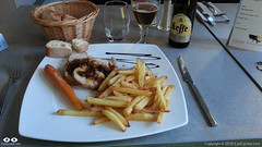
    Dinner at the Auberge de Villequier
    Dinner at the Auberge de Villequier

    The concept of “nearby” changes when you are travelling on the bike though. It took me almost 1h riding in the wrong direction (as I found out the next day) to get there, but the Auberge is lovely and the owners were very nice to me. The room was small, but big enough to wash and dry my wet clothes and dry the tent and camping equipment. Also enjoyed a very nice meal that night, my personal reward for a hard day of cycling under rain.

  • Took very few pictures during the day. The rain was the biggest contributor to this, but in all honesty I did not feel like there were a lot of picture worthy moments anyway.

Back to Top

Video of Lightfoot Guide Stage 15, from Péronne to Trefcon

Video Length: 4 min and 45 sec
To skip introductions and recommendations jump to time stamp 0:40 in the video timeline.

Back to Top

Video of Lightfoot Guide Stage 16, From Trefcon to Tergnier (and further to the Auberge de Villequier)

Video Length: 9 min 42 sec
To skip introductions and recommendations jump to time stamp 0:38 in the video timeline.

Back to Top

Pictures of the day.

Click on any picture for full detail

Back to Top

If you have any questions, don’t hesitate to comment or send me a message through the contact form.

Please subscribe to my Blog and/or to my YouTube channel if you don’t want to miss the next one and help me spread the word by liking and sharing my Facebook Page and Tweeter feed also.

Thank you for your time!

Please rate this post by clicking on the desired star (1 = Awful, 5 = Excellent)
[Total: 2 Average: 5]

04/29. Via Francigena, Peronne to Tergnier (Auberge de Villequier) [GPS File]

This GPS file represents the route I took between these two locations during my Via Francigena pilgrimage by bike from Canterbury, in the UK, to Rome, in Italy.

The route contains mistakes and tracks I may not recommend you to take, so it is important to read the respective posts for more context.

Use of this resource at your own risk.

Please rate this post by clicking on the desired star (1 = Awful, 5 = Excellent)
[Total: 0 Average: 0]

Via Francigena, Day 4 and 5 (2 and 3/Aug): From Peronne to Tergnier (Auberge de Villequier) and to Reims

In this post…

  1. Day 4, 2nd of August 2016, ride between Péronne and Tergnier (Auberge de Villequier)
  2. Day 5, 3rd of August 2016, ride between Tergnier (Auberge de Villequier) and Reims

Day 4, Tuesday, 2nd of August 2016: From Peronne to Tergnier (Auberge de Villequier)

The night in the tent was not good. It rained all night and I am not used to that kind of “rain on tent” noise. The morning wasn’t different. When I woke up is wasn’t raining, but by the time I was finished with my breakfast it slowly started to come down again. I managed to pack everything just in time when the rain started to thicken.

Google Maps guided me out of town through some very muddy dirt tracks, which wasn’t nice. That is one of the problems with the “beta” cycling navigation of Google Maps. There is no option, as far as I know, to tell it not to trace a route using dirt tracks (off-road). I did manage to get through the mud without an incident (barely) and few kilometres down the track re-joined a “D” road.

The destination was Trefcon and I was expecting it to be small, but not that small. It is really only a few houses together and as expected there wasn’t anything open, nor anyone around.

So, took a few pictures and continued to Tergnier.

The rain is always an annoyance when riding a bicycle, but the big enemy of his day was the wind. You may have notice I had a little orange flag in the back of the bike to improve visibility. Well, the wind was so strong it managed to rip the flag and flag pole from the base without me noticing it. Since then I am riding Flagless 🙁

The 2nd victim of the day was my “side-open” GoPRO case, which I used to be able to charge the GoPRO while recording. He locking lever broke, but the case seems to be holding close well with an elastic band.

I arrived in Tergnier soaked, tired and with a bad mood. As I got there I asked a few locals for a hotel, but I couldn’t understand the directions they were giving me. So I turned to Google and the 1st option Google gave me was an Auberge in the “nearby” village of Villequier). In the Google Maps description, it said it was 4.2 Km from Tergnier, but it turned to be 7 Km, as measured by the Garmin… and in the wrong direction. Can’t really blame Google for that (except for the distance) as I should have looked more. Tergnier is small, but there are apparently a few hotels there.

Anyway, I was settled for the night and manage to hand wash some of my clothes as well as dry a bit more the tent. Didn’t really take any pictures this day as it was raining most of the time and I didn’t feel there was anything picture worthy along the way.

Day 5, Wednesday, 3rd of August 2016: From Tergnier (Auberge de Villequier) to Reims.

I had just finished packing and started to rain. It rained for about 1 or 1.5h, but at least the wind wasn’t as strong as the day before and that enabled me to ride almost 90 Km this day. I started by taking the exact same way back to Tergnier as I did the day before. I wanted a Tergnier stamp on my pilgrim’s passport and I had a remote hope to find my flag again (which I obviously didn’t… just wishful thinking).

After receiving the Tergnier stamp from the Hotel de Ville on the credentials, I headed to the next stage in the Via Francigena Lightfoot guide which is Laon.

Laon was probably the high point of the day, but to get up there wasn’t easy. Had to dismount and push the heavy bike most of the way up. You get rewarded by the beautiful cathedral and the views, once you get up there. Managed to get my pilgrim credential stamped in the Tourist Information Office and when I looked for a place to rest and eat something I was told it was closed (I don’t understand the French economy… it was barely 4 pm I think).

While I was taking pictures a group of Dutch cycle-tourists came to talk to me. They were curious about my gear and my pilgrimage. One of them was kind enough to take a few pictures of me with my camera.

The next stage after Laon is Corbeny and, as expected on these little villages, everything was closed, even their hotel. Jeanne D’Arc apparently had stayed in Corberny on he 22nd of July 1429, so she was luckier than me to find anything open that day. Took a few pictures and continued, but feeling a bit disappointed by all these small French villages I decided to skip he next town in the guide, which was Hemonville and head straight to Reims, which is a much bigger city and a place I wanted to visit anyway. So, if there was something worth seeing in Hermonville you’ll have to find out by yourselves.

It was on my way to Reims that met Fabio, the 1st Via Francigena pilgrim I have seem. Fabio lives in Rome, so he travelled to Canterbury and is walking back home… home to Rome. I gave him one of my cards and I hope he gets in touch to share his experiences, eventually.

Reims has a most impressive cathedral as well, so bug, in fact that it was hard to frame it all too close. Unfortunately, I didn’t get to enter it, as it was already late and I had to find a place to sleep still. As I got to Reims, around 7:30pm the tourist information office was already closed, but they have an interactive, touch sensitive display in front of the office which was very helpful. It allowed me to search for accommodation by a number of criteria, such as price, location, etc. I manage to get the address of a cheap hotel just 2 blocks away and by luck they still had rooms available.

I had a walk around the town centre in the evening before dinner and was most impressive by how lively it is. I loved the colour changing buildings (the light shining on them obviously changes colour), such as the opera house and a few other buildings I could see. I wish I had more time to spend there.

Hope the pictures talk for themselves, but if they don’t and you are curious, just get in touch through the contact form on the menu (it may take me a few days to answers, though)

And, if you got to this point, 1st I hope you enjoyed the account and 2nd as usual, before I close this post, how about you donate to my charity of choice, Mind UK, one of the UK’s leading mental health charities? Anything you can donate will be a big help.

Thank you!

Please rate this post by clicking on the desired star (1 = Awful, 5 = Excellent)
[Total: 3 Average: 5]