it gives me great pleasure to announce to you all that next week I will start my 3rd Christian Pilgrimage by bike. It’s called “Caminho da Fé” which literally translated to English means “The Faith’s way”, but it is also sometimes translated as “The walk of faith”. This pilgrimage route is now considered to be the Brazilian equivalent of the way of St. James or Camino de Santiago, which I’ve done in 2015.
There is extensive material about the “Caminho da Fé” on the Internet, but in Portuguese only. I could not find much in English, so the English version of this post will be more detailed than it’s Portuguese one, so to give you guys more background information of what the pilgrimage is all about (most links on these page will open to English Language resources though).
Brazilians have been walking to the Basilica of the National Shrine of Our Lady of Aparecida for generations. Many to fulfil religious promises (i.e. to obtain a cure for some illness or for other types of graces), others for cheer devotion. With 18,000 m2 (190,000 sq ft), the basilica is the 2nd largest catholic church in the world losing only to St. Peter’s Basilica in Vatican City.
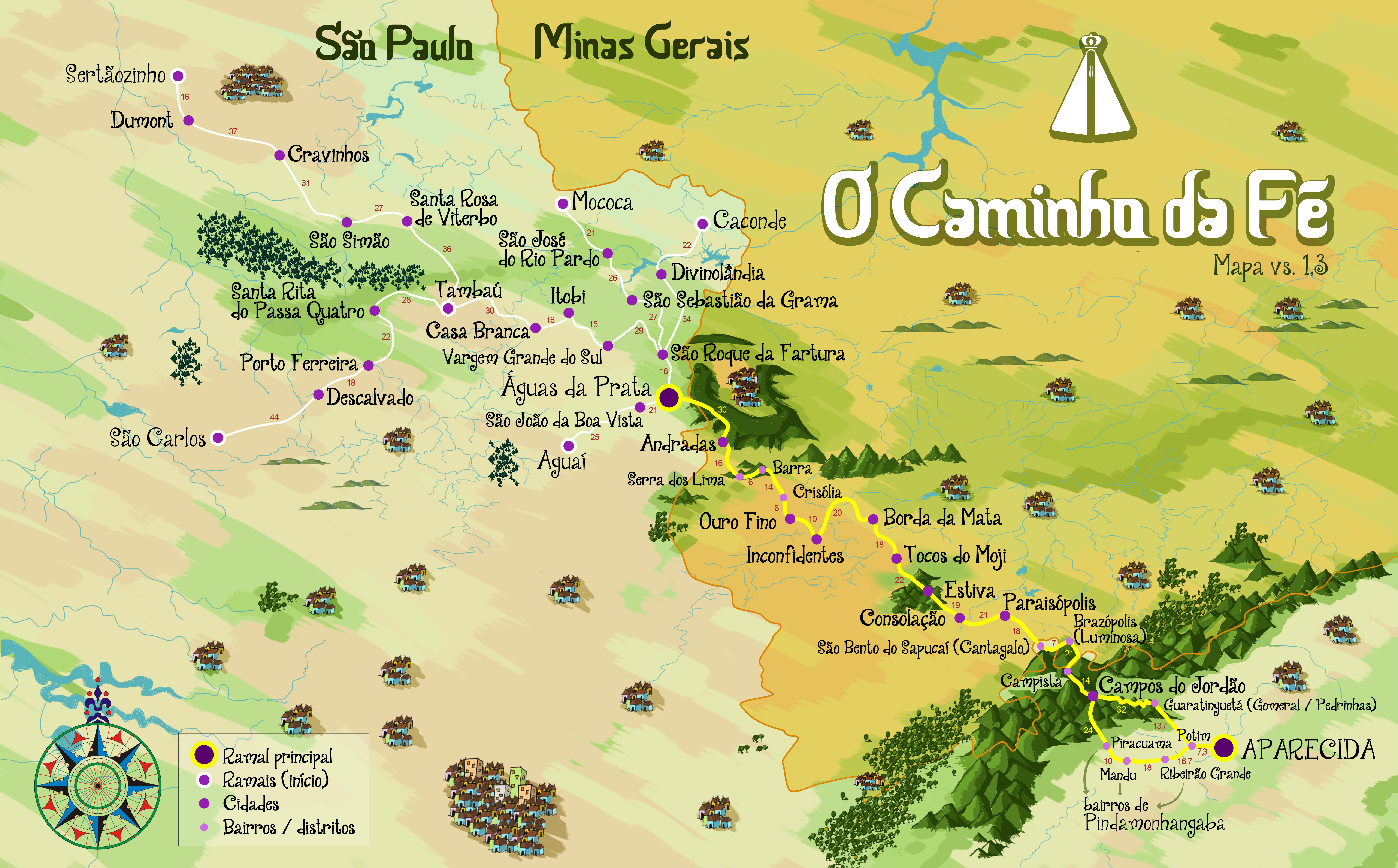
Map of the “Caminho da Fé” (click to open. Source AACF)
In 2003 a group of pilgrims who had walked to Santiago de Compostela a couple of times decided to create a pilgrimage route between Aguas da Prata in the Federal State of São Paulo and the Basilica, in Aparecida do Norte, 318 Km away on the designed route (walking paths). Currently, however, the route has many, so called, “branches” all of them starting from different cities, but passing through Aguas da Prata, on the original route designed in 2003. These, in turn, have also a few options which may increase or decrease the distance between the starting point and Aparecida do Norte. The branches are as follows:
#
Branch
Distance in Km
Option 1: Via the town of Pindamonhangaba
Distance in Km
Option 2: Via the town of Guaratinguetá
1
Aguaí to Aparecida
364
341
2
Aguas da Prata to Aparecida
318
295
3
Caconde to Aparecida
390
367
4
Mococa to Aparecida
408
385
5
São Carlos to Aparecida
536
513
6
Sertãozinho to Aparecida
571
548
7
Tambaú to Aparecida
424
401
Source: AACF (Friends of the “Caminho” Association. Site in Portuguese only)
I’ve chosen the longest path, starting from Sertãozinho, not necessarily because I want to ride more (although this was one of the reasons), but because of logistics. There is a direct bus from my current whereabouts to Ribeirão Preto, a city only 20 Km from Sertãozinho, so I only need take 1 bus journey (of 12 h though) to get to my starting point.
My entire journey will start on the early hours of Sunday, the 18th of September, with the bus to Ribeirão Preto. From Ribeirão Preto to Sertãozinho there is a short distance of just over 20 Km, perfectly doable by bicycle, but I’ve been advised to avoid this track because it goes through some high crime areas between the 2 towns (in Brazil, unfortunately, this is a constant worry).
So, as I arrive in Ribeirão Preto I may take yet another bus journey, a short one though, to Sertãozinho, or, if I am feeling adventurous, ride my bike (generally speaking armed thieves steal the entire bike with everything on it, and on the rider… it would be a shame if my pilgrimage was to end before it could even begin though).
In Sertãozinho I will overnight in the Agapito Hotel, one of the few places where you can buy the pilgrim’s credentials, which, exactly like in the Way of Saint James, you will need to stamp along the way in order to obtain the certificate of completion as you arrive in the Basilica in Aparecida do Norte.
Typical “Caminho da Fé” Pilgrim’s Credentials (extrenal link. Click to open it on source site)
From Sertãozinho I’ll let faith take me (no pun intended). I was going to purchase the excellent “Caminho da Fé” guide (link in Portuguese only) from Antonio Olinto, but I didn’t get to do it, so I will simply follow the yellow arrows (another thing copied from the the way of St. James / Camino de Santiago).
My two previous pilgrimages experiences taught me a lot and minimised a number of fears I had before I started. This one, in Brazil, is a bit different than the previous two as it introduces the fear of being victim to the social / economic situation of the country. Not that being a victim of crime isn’t a possibility during the Camino de Santiago where even murders of pilgrims are know to happen, but it is a question of the likehood of it happening, which in Brazil is much higher than in countries of the European Union.
The good thing about starting my pilgrimage on the 19th of September, though, is that I apparently will not be doing it alone, as I originally thought I would. I found out today that a crew of the Brazilian TV network “Globo” will be recording a program about the “Caminho da Fé” and that the main reporter, who I had the pleasure of talking to on the phone today, will also be riding on a bike all the way to Aparecida, supposedly followed by his TV crew. Who knows, I might even appear on the telly, which is an unexpected surprise. Life does have a way to surprise you, if you give it a chance.
As usual, I will try to post as much as I can along the way, but experience has thought me that any posts are more likely to happen on the EyeCycled Facebook page than on the blog. So, please, if you have not done so yet, and would like to follow me on this little adventure, make sure you like the page.
If you’ve seen my previous post, you’ll be aware that I recently lost a “non-human” friend, my trusted Dell XPS 15 notebook, which I used to edit the videos for the YouTube channel and create content for the blog. As with previous pilgrimages, I fully intent to cover the entire route of the “Caminho da Fé” with time-lapsed videos and bring as much info and media to you as possible. Without a proper computer that might take awhile though, but don’t give up on me. Like “Arnie”, I’ll be back!
“Buen Camino!” or in this case “Bom Caminho!”
PS. If you can read in Portuguese, the site of the AACF (Friends of the “Caminho” Association) is an excellent source of information.
Post about the 4th (and 5th) day of journey, published on 10th August 2016
This post complements the post I published on the 10th of August 2016 in which I described the experiences I had while riding between Péronne and Tergnier, including the additional (and unnecessary, might I add) ride from Tergnier to the Auberge de Villequier, where I spent the night. I am not going to repeat the contents of that post in this one again, but I will add a few highlights for each stage below. I encourage you to read the previous before continuing on this one.
To go or not to go? Woke up many times during the night to the sound of heavy rain. In the early morning I decided to wait in the tent to see if the rain would stop. It meant that by the time I was done with breakfast and packing it was past 11am in the morning, but I think it proved to be the right decision this time (aided by some weather forecast on the phone). Wasn’t really looking forward to packing my gear under rain. The rain resumed just after I left, so I guess I can consider it a lucky dry window, just long enough for me to pack my gear.
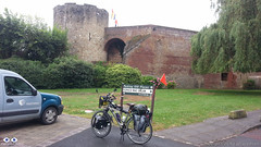
Château de Péronne
After leaving the Camping Site the first stop was at Péronne’s tourism information office in the town centre to collect a stamp on my Pilgrim’s Credential. As I was late I couldn’t really explore the town. As with many other towns and villages I’ve been through, Péronne looked like it would have been worth at least a few hours, if I had time to spare.
Again and again, Google Maps is good, especially to those like me that are “navigation challenged”. One problem for cyclists is that it tries, as much as it can, to guide the cyclists away from heavy vehicle traffic. Yes, this is good, but it also means it guides you to paths that during or after heavy rain might be very challenging to transpose. As I left Pèronne Google Maps instructed me to leave the “D” road I was to some dirt paths that were very muddy, only to guide me back to the same “D” road about 1.5 Km later. When you don’t know the way, the decision is not always easy. Overall Google Maps helped me more than it hindered me though.
The ride to Trefcon was uneventful and the village itself is tiny and it appeared to be completely deserted.
It rained basically all day that day (on and off) and after leaving Trefcon the route was mostly on good roads up to the town of Montescourt-Lizerolles, where Google Maps instructed to take a path alongside the railway. The terrain was somewhat challenging as the Swalbe Marathon tyres I have in the bike are not really suited for them. After overcoming the path, I decided not to follow the route Google had planned and take my chances on the major “D” road, the D1, that took me straight to Tergnier. The traffic was intense and the road had guard-rails and no hard-shoulder. I don’t recommend this route, but on hindsight I believe it was the right decision, albeit somewhat riskier than to stick (no pun intended) to the dirt paths.
Riding under constant rain is not really fun, but the main challenge, besides the muddy paths, was the strong wind which slowed me down considerably and took away the high visibility orange flag I had in th back of the bike. I arrived in Tergnier tired and feeling a bit ill, probably due to the wet conditions (I am slightly asthmatic and humidity is not a good thing for me). The town hall was closed, so I turned to Google again for a place to sleep and the 1st option Google gave me was a hotel / hostel in the nearby village of Villequier.
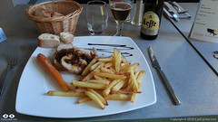
Dinner at the Auberge de Villequier
The concept of “nearby” changes when you are travelling on the bike though. It took me almost 1h riding in the wrong direction (as I found out the next day) to get there, but the Auberge is lovely and the owners were very nice to me. The room was small, but big enough to wash and dry my wet clothes and dry the tent and camping equipment. Also enjoyed a very nice meal that night, my personal reward for a hard day of cycling under rain.
Took very few pictures during the day. The rain was the biggest contributor to this, but in all honesty I did not feel like there were a lot of picture worthy moments anyway.
If you have any questions, don’t hesitate to comment or send me a message through the contact form.
Please subscribe to my Blog and/or to my YouTube channel if you don’t want to miss the next one and help me spread the word by liking and sharing my Facebook Page and Tweeter feed also.
Thank you for your time!
Please rate this post by clicking on the desired star (1 = Awful, 5
= Excellent)
VF post from 8AUG16, from Bruay-la-Buissière to Péronne
This post complements the post I published on the 8th of August 2016 in which I described the experiences I had while riding between Bruay-la-Buissière and Péronne. I am not going to repeat the contents of that post in this one again, but I will add a few highlights for each stage below. I would strongly encourage you to ready the August, 2016 post before continuing on this one, though.
Via Francigena can be just bike touring, of course, but if you want your Testimonium when you get to Rome, you have to present your pilgrim’s credential and it needs to have stamps in it. They do do a deep analyses of the stamps, but they will expect that in a 2,000 Km bike ride you will have collected a few. In the digital age is getting more and more difficult to find stamps… so analogical (illogical?). In many of the small towns and villages the chance of you to find a government facility (town hall, tourist information office, etc) will depend on the day of the week (Weekends? No chance) and the time of the day as some of these facilities will be closed, e.g. lunch time, or may have public opening hours. I really tried getting my pilgrim’s credential stamped but as it was the case in Ablain-Saint-Nazaire and others, as I got there I could not find anything open. Even the pharmacy was closed.
Arras is spectacular. Worth a visit if you can afford staying for a day. It’s a UNESCO World Heritage site and is more than 2,000 years old.
There is a “Route 66” café in Ervillers, between Arras and Bapaume, with a big statue of “the King” (Elvis). Coming across that reminded me of a friend who was about the ride the entire route 66 by bicycle. Her name is Cacá Strina. Check out her page here.
Don’t completely trust technology. Have always some low tech option to fall back if technology fails you. For some reason I lost GPS connection between Baupame and Péronne and I was relying on Google Maps entirely. At the very least download the offline maps over a WiFi connection, if possible, before you leave. Getting to Péronne was no problem, I simply follow the signs, but finding the Municipal Camping site took some time and effort (about 5 Km more than necessary).
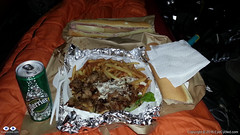
Tent Feast (Large Kebab Plate)
By the time I setup camp, had a shower and was ready to go out to find something to eat, the nearby supermarket in Péronne was already closed and after almost 30 min walking the only place I could find was a kebab trailer. So I ordered an extra large Kebab plate for dinner (and a baguette sandwhich for breakfast next day) and had a feast in the comfort of my tent. In small towns it may not easy to find a place for a meal at night. Keep that in mind.
Video of Lightfoot Guide Stage 14, From Bapaume – Péronne
Video Length: 5 min 38 sec To skip introductions and recommendations jump to time stamp 0:40 in the video timeline.
The next video is a time-lapse recording of my “awesomely akward” tent pitching skills. Took me “only” 20 min to pitch the tent. Thank God I don’t do this for a living… 🙂
In the municipal camping site of Péronne in France. Between the 3rd and 4th day of my Via Francigena pilgrimage. It raining a lot during that night and in the morning. Didn’t have a good night of sleept that day.
If you have any questions, don’t hesitate to comment or send me a message through the contact form.
Please subscribe to my Blog and/or to my YouTube channel if you don’t want to miss the next one and help me spread the word by liking and sharing my Facebook Page and Tweeter feed also.
Thank you for your time!
Please rate this post by clicking on the desired star (1 = Awful, 5
= Excellent)
"Life is a pilgrimage. The wise man does not rest by the roadside inns. He marches direct to the illimitable domain of eternal bliss, his ultimate destination", Swami Sivananda
This post complements the post I published on the 2nd of August 2016 in which I described the experiences I had while riding between Alembon and Bruay-la-Buissière. I am not going to repeat the contents of that post in this one again, but I will add a few highlights for each stage below. I would strongly encourage you to ready the August, 2016 post before continuing on this one, though.
Route:From the Rural Gite in Alembon to the Ibis Style Hotel in Bruay-la-Buissière via Licques, Tournehem-sur-la-Hem, Thérouanne, Amettes and Bruay-la-Buissière
Distance: 86.02 Km
Departure time from Alembon:10:29am
Arrival at Destination:5:58pm
Duration of day’s Journey:7h 29min
Expenses this day:Total = € 99.00
€30.00 – Food
€69.00 – Accommodation (Ibis Styles Hotel Bruay-la-Buissière)
Everything was going well, until… The unexpected, yes the unexpected again… By 9:30am I had packed everything and was ready to leave the Gite. I then realised my CatEye cycling computer was missing. Looked in the front bag, as I was certain I had put it there the night before. Wasn’t there, of course. Went back to the room and looked everywhere as I thought it might have fallen of the front bag during packing. Wasn’t there, of course. So all what was left was to look for it in the panniers, which were already neatly locked to the bike. Well, a pilgrim has go to do what a pilgrim has got to do. Looked for it in the front panniers as these were a lot easier to remove. Not there, of course. Took everything off the back of the bike again and looked in one pannier (not there, of course) and then the next, and bingo! It had fallen into the pannier as I was packing my things. I was happy not to have lost it, although I knew it was with me the night before, but the unpacking and packing took me almost 1 full hour. I didn’t do that mistake again…
Do not underestimate the SUN! The day before had been rainy and not particularly hot.
50 Shades of Red
I had seen on the phone’s Weather App that this day was supposed to be cloudy, but not rainy. It didn’t occur to me that I no longer was under British Weather. The day turned out to be very hot and sunny and I hadn’t passed any sunscreen on my skin. By the middle of the afternoon I was already feeling the damage the sun had done to my skin, which now looked very burned. The sunscreen was on the very bottom of one of my rear panniers. I should have stopped and passed the sunscreen on, but the thought of removing everything on the back of the bike (I had an intricate system there) was not appealing, so I continued. By the time I realised my mistake it was too late. The result was some heavy sun burns and sun fever by the time I got to Bruay-la-Buissière. As it was Sunday I knew it wouldn’t be easy to find accommodation and I wasn’t feeling very well so I used Google Maps to show me the available hotels nearby and the most affordable was the Ibis Style hotel 5 Km away from the town centre.
Video of Lightfoot Guide Stages 10, From Amettes to Bruay-la-Buissière
Video Length: 6 min 05 sec To skip introductions and recommendations jump to time stamp 0:48 in the video timeline.
The next video was recorded as I was crossing the town of Marles-les-Mines, between Amettes and Bruay-la-Buissière and their Folkloric group parade was about to start at the town’s FÊTE FORAINE.
If you have any questions, don’t hesitate to comment or send me a message through the contact form.
Please subscribe to my Blog and/or to my YouTube channel if you don’t want to miss the next one and help me spread the word by liking and sharing my Facebook Page and Tweeter feed also.
Thank you for your time!
Please rate this post by clicking on the desired star (1 = Awful, 5
= Excellent)
Post about Via Francigena, Day 1, written during the pilgrimage.
Introduction
This post complements the post I published on the 30th of July in which I described the experiences I had while riding between Canterbury and Alembon.I don’t think I need to repeat the same things here, so if you didn’t get a chance to read about this day on that post, I would strongly encourage you to do so before continuing on this one.So, in this post I am skipping the story and just adding some data, the GPS route, the pictures and the videos of that day’s ride.
Do not ride on the A2! Use the improved Lightfoot GPS route which you can download from here (Scroll down to the “Bike Touring Route” section and clink on the + to expand). Also read / watch my post / video from the 8th of June 2016 of my bike ride between Canterbury and Dover on the Regional Cycle Route 16, which more closely matches the official route. The GPS route I took that day is available in that post.
Rain and bad weather in the UK and strong sun just after crossing the channel.
If you don’t have time to get a stamp on your pilgrim’s credential in Dover, after you board the ferry go to the information desk on board and ask them to stamp your credentials. Better than nothing.
In Calais and other towns, do use the services of the tourism information offices, if you can. You can always get your pilgrim credentials stamped there, but keep in mind that during the weekends or certain times during weekdays they are most likely closed, especially in small towns.
When you buy a new SIM card for your phone abroad, it can take quite some time until it properly registers on the network and you have full access to the Internet again. Download offline maps if using Google Maps for Navigation or use something that does not rely on an internet connection (I used Garmin Navigation
Gite in Alembon
If you cannot find pilgrim accommodations, where available, stay at a rural Gite. They are cheap and the people are very nice. I totally recommend the one I stayed in Alembon if you want to stop there. Keep in mind Alembon is a tiny village. There is nothing to do around, I mean, no restaurants, shops, etc, but if my experience is a reference Madam Levray will take very good care of you. She is very used to having pilgrims in the house. Before me she told me she received a pilgrim’s couple who were doing the pilgrimage on horsebacks I believe.
Video of Lightfoot Guide Stages 01 and 02, from Canterbury to Dover Ferry Port (UK)
Video Length: 6 min and 14 sec To skip introductions and recommendations jump to time stamp 1:17 in the video timeline.
As I mentioned above and in my earlier post if you are planning on riding between Canterbury and Dover (either as a pleasure ride or as part of your pilgrimage) I do NOT recommend you do what I did. Do not take the A2. The reasons for this recommendation would be self-evident if you watched the video above.
I know I am repeating myself here, but I feel some repetition is granted. I recommend you either follow the Lightfoot Improved GPS route (which link to download is up above) or follow the same route I took on June 2016 on the regional cycle route 16. For your convenience the video of that route is down below.
… and this is how the Cathedral looked like on that sunny day in June 2016…
If you have any questions, don’t hesitate to comment or send me a message through the contact form.
Please subscribe to my Blog and/or to my YouTube channel if you don’t want to miss the next one and help me spread the word by liking and sharing my Facebook Page and Tweeter feed also.
Thank you for your time!
Please rate this post by clicking on the desired star (1 = Awful, 5
= Excellent)
I honestly tried to publish content about my Via Francigena Pilgrimage by bike last year, but life got in the way and the ideas I had in my head for the blog posts and videos were perhaps a little out of my league.
Some time ago, as I was editing the 3rd video, I believe, I decided that I before I started the series of Via Francigena Blog posts I should publish an introduction first. I looked back into my “old” plans and realised things didn’t quite go as planned, but that they could probably have the potential of being worst if I hadn’t planned.
This introduction allows me to share my original plan with you and compare it with some of the real life post-pilgrimage information I collected. Perhaps it can be useful to other pilgrims.
In this introduction I also want to explain why I will be doing things in a certain way (by “things” I mean, the posts, the videos, etc). Call it the publishing “strategy”, if you like.
So, here it goes… the introduction to my Via Francigena Blog Series.
Click on the links below to jump directly to that section.
I could answer this with “Google is your friend“, or I could just provide a number of links to web resources such as this one, this one and this one, but they would not be my answer or at least answer what Via Francigena was to me.
In 2015 a friend and I decided to do the Camino de Santiago by bike. I had done some shorter bike trips before, but this was, at the time, the longest bike ride of my life. I loved it! Since coming back I was looking for the next challenge. For various reasons a number of ideas were raised and dropped. Some would take too long and be too expensive requiring me to take a license from work or quit my job. Not quite sure how I got to know about the Via Francigena (VF), but as a pilgrimage it is quite akin to the Camino de Santiago, so much in fact that is often also called “Camino di Roma” and it was probably during my research to write about my experiences with the Camino that I came across the details for the VF.
I really needed a challenge to get my mind off certain things that were consuming me during that period. Therapy and medication wasn’t helping much, so I started planning and the more I put my head to it, the more I was certain it was a feasible adventure, not too hard and not too easy. I found out that I was OK to spend the expected amount of money needed, but getting the approval from my company for the extended holiday period required for the trip, plus a few extra days for contingencies, wasn’t too easy.
It took me 29 days to complete the pilgrimage end to end, so my plan is to write at least 29 posts, as short as they may be, one for each day.
To promote consistency and order to the posts, I will divide each post in the respective Lightfoot Guide stages I covered on that day. More about the Lightfoot guide stages below.
For those old enough to understand this, it is not only Frank Sinatra that did things in his own way… I did my Via Francigena in my own way too… but, of course, like the Beatles (and Joe Cocker) with a little help from my friends.
First I bought the electronic version (PDF) of the Via Francigena Lightfoot volume set, containing 4 volumes. I do recommend them to you, but to be brutally honest, I don’t know if it was a worthwhile investment for me.
Lightfoot Via Francigena Guides, 4 Volumes
You can acquire the guides in paperback format at a cost of €67.99 or in digital PDF format at lower cost of €38.99 (at the time of writing) which comes watermarked with your name and email address to prevent misuse. I would recommend the e-book version as you honestly would not benefit from carrying 4 volumes of books, with hundreds of pages each, on your bicycle panniers (or backpack if doing by foot).
Although the guides are extremely detailed, I’ve personally found the maps very confusing to follow on my bike, but, please, don’t take me as reference as I am a terrible map reader anyway. I believe they would be a much better help to those doing the pilgrimage on foot. The most useful aspect of the guides for me was to provide direction, hints and tips and the list of pilgrim accommodations.
The Lightfoot guide divides the Via Francigena into 98 stages, which are, presumably, the segments covered by Archbishop Sigeric, the Serious, on his 80 days return journey from Rome to Canterbury after receiving his Cope and Pallium (a circular band of white wool with pendants, worn by archbishops) from the Pope.
I deliberately missed some of these stages, such as the one from Calais to Wissant, and a few more during the journey because of various reasons, but I did cover most of these stages and the posts and videos will focus on them for each day of the pilgrimage.
You will be able to download the GPS files of the routes I took every day, but they include mistakes and tracks I would not recommend to you, so it would be important to read the posts for some context if you want to avoid making the same mistakes I did.
I am an Engineer by formation and a project manager by trade. With this in mind, how can you expect me to go into anything without at least a minimum amount of planning? It is in my nature…
So I am making available here the original planning document in PDF format. I don’t mind sharing the original Microsoft Word document, nor any of the other supporting documents (Excel Spreadsheets, Microsoft Project Plan, PowerPoints, etc), but if you want them you’ll have to message me requesting them. They might be useful to you, if you are planning on doing your own Via Francigena.
Keep in mind, they should only be used as a guide. When I did the Camino de Santiago in 2015 I heard many times that although the route might be the same, the Camino is different for each person. That is one of the truths about pilgrimages: The Camino is yours… a very individual thing. Even if you do it more than once, they will always be different. When I did the Camino de Santiago in 2015 I met pilgrims who had done it several times and confirmed to me that every time they did it, was different, even if walking or riding the exact same route. That is perhaps one of the things that make this type of adventure so appealing to many. There will be decisions to be made along the way and a variety of random things that may force you to change your plans or your route, like road closures, weather conditions, sickness, mechanical failures, little accidents and so on… (knock on wood).
I know this may sound ridiculously obvious, but I don’t think I can over-emphasize that you should not rely too much on other people’s experiences as a recipe for success, if there is such a thing as a successful pilgrimage.
Now, this is not going to sound positive in terms of my planning skills, but no plan I’ve ever made worked out 100%. Other project managers might understand and accept this, however, one thing stands out with project planning: “Fail to plan is planning to fail”. At the very least a good project plan gets you thinking about what you want to achieve and how to achieve it. It is no guarantee of success, especially if you never done before, whatever you are doing, but it is better than to face the challenge completely unprepared.
I decided not to write a lengthy analysis about the things that worked and the things that didn’t. At the end of this series I may do that, but by then, if you have the intention of following the series, you’ll probably know that already.
I attempted to collect a lot of data during the journey, and that failed. I think I over-estimated my ability to do the collection while ensuring I was on the right track, got to the top of that mountain and was not run over by a truck or a car. It is a lot to take in and I had my hands full most of the time, but it wasn’t a complete disaster either.
Those that have done any amount of cycle-touring in their lives will know that at the end of the day you will be tired, dirty and hungry. The last thing on your mind would be “I need to record the stats / log for the day”. It wasn’t easy to get in front of a computer to write anything after a challenging day of riding 8 to 9 hours on a bike, yet I did it most days (feel free to leave me your kudos in the comments).
I was using multiple files as I originally thought it would be easier to separate the information, but upon my return I combined everything into a single file which I make available for download below. It contains all of the expenses, categorized by food, accommodation, repairs, transportation and extras as well as route and track information and a few other “bits and bobs” which might be useful to those attempting to do the same. I originally planned to collect information about other pilgrims, signage along the route and so on, but that was too much.
Video creation is by far the most consuming task in the project. I learned that after coming back from doing the Camino de Santiago in 2015. While it took me about 2 weeks to complete that pilgrimage, it took me a year to write about it and that is alright, after all this is my hobby and not my day job.
After the “Camino” I produced at least 1 time-lapsed video for each day of the journey. Some of these videos became a bit too long and I became a bit frustrated that after all the work I had put in them, almost no one was watching them ’till the end. So, for this series of posts I decided on a different approach: I’ll create shorter videos, more specifically breaking them down by stages, the same stages defined by the Lightfoot guide I used. Although there are 98 stages in the guide, I don’t expect to produce 98 videos as I skipped some of the stages.
As the videos were recorded in time-lapse mode with a GoPRO 4 Silver, that means they are very shaky and fast (the series 4 does not have digital image stabilization built in), so I want to leave a few hints and tips on how to best use the videos. I thought the best way to do that would be in a video itself, so, here it goes…
The photos will all be in Flickr as I found media to be very difficult to handle in WordPress itself. There will be albums containing all the photos for each day of the journey and all albums in be joined in what Flickr calls a “collection”.
Unfortunately, if you want more context to the photos you’ll have to read the blog posts as I simply don’t have the time and the will power to write descriptions for each of the thousands of pictures there.
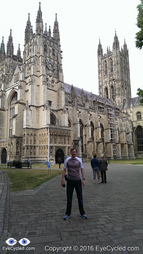
I live in a small town called Bracknell in the county of Berkshire, England. The distance between my home and Canterbury is roughly 100 miles or 160 Km, so I got a good friend of mine to drive me to Canterbury the day before. I also had the company of my older son.
I had a reservation at the local Youth Hostel and after leaving the bike and gear in the hostel we all left to walk around Canterbury and find a place to eat dinner.
You can read a lot about Canterbury in Wikepidia, so I will just refrain from copy and pasting and leave you the invitation to click on the link above to learn more about this historic town, a UNESCO World Heritage Site, which has been inhabited since pre-historic times and played an important role in British history.
There isn’t actually much more to say about that day. After having dinner, my friend and my son drove back home and I spent some time in the hostel writing this blog post here.
At that point I was still deluding myself that I would be able to write one short post for each day of the journey. I did write several, but I now know better.
I don’t want to repeat in this post what I wrote on the above mentioned one, but I thought it was OK to, at least, point back to it and also share the pictures of the day.
Please subscribe to my Blog and/or to my YouTube channel if you don’t want to miss the next one. Please help me spread the word by liking and sharing my Facebook Page and Tweeter feed also.
Thank you for your time!
Please rate this post by clicking on the desired star (1 = Awful, 5
= Excellent)
quick post just to let you know that I did not abandon the Blog… 🙂
I am working on writing Via Francigena content, editing the videos and sharing this experience with you, but progress has been slow due to life’s demands. Please, subscribe to be informed of new post or like our Facebook page.
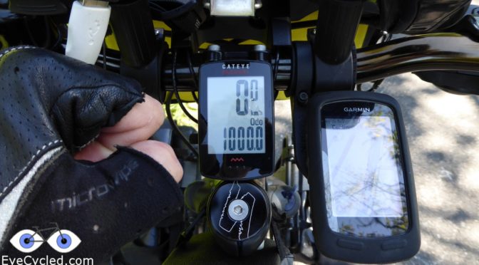
On the 12th of August 2016, the 14th day of cycling between Canterbury and Rome, I completed the 1st 1000 Kms of daily bike riding of my life.
I know, compared to cyclists that cycled around the world, some of which with 100s of 1000s of Kilometers in their Odometers, just is just a drop in the ocean, but for me it was a pretty special moment in a nice location.
The pilgrimage has ended now and I am back in the UK to my “normal” life. I end up having cycled 2,043 Km when I arrived at Saint Peter’s Square in Rome. Was an experience I will cherish forever, but I somehow don’t think it was the experience of a life time. Not ready for the grave yet… 🙂
New challenges are definitely on the horizon.
Thank you your time!
Please rate this post by clicking on the desired star (1 = Awful, 5
= Excellent)
Day 12, 10th Aug (Wednesday): From Besançon to Pontarlier (77.73 Km)
The day started with a French breakfast in the hostel’s cafeteria in the company of Nathalie, whom I met the day before. Breakfast done, goodbyes said was time to get all the mess sorted, take the bike out of the bike garage and move on. Was great to get to know Besançon, but at this point I was still concerned in not taking too much time in one single place so I had enough time to fix things if anything went wrong. At this time the crossing of the Great Saint Bernard was still an unknown challenge to me.
The next destination was Ornans, stage 41 on volume 2 of the Lightfoot Via Francigena guide.
The ride started with going back to the centre of the city and riding a few kilometres alongside the river Doubs which crosses Besançon.
As I was taking pictures of the Citadel from the river side I remember thinking, thank God I don’t need to ide up there and then I looked at the route Google Maps traced and that was exactly what it was suggesting me to do. I spent several minutes evaluating the maps and could not see a suitable alternative, as other routes appear to required me to climb up there anyway, just from different directions. So, in for penny, in for a Pound and the British say. Little did I know at the time I would have to go much higher and in a distance of just 4 Km I probably had to climb 350 m of very steep roads to Chapelle des Buis, some of it I had to dismount and push as the angle of ascent was more akin to a staircase than to a road. The view from up there was quite nice though.
After Chapelle de Buis Google was directing me to take a dirt track and not to make mistakes of days past I decided to ask for directions from some locals who were walking up the road. They said “No, No… tout a droite” and directed me to continue downhill on the road I was on and always keep to the right. Yeah, that also proved to be a mistake or I didn’t understand their instructions properly. Took me at least 45 min to get back on track and I had to partially ride the hill up again and push the bike on a steep dirt track up as a bonus.
As I arrived in Ornans I wanted to post some pictures and then I realised the credit on my French SIM card had expired. That meant no Internet. Since I believed this would be my last day in France, I decided not renew the credit and rely on Garmin for navigation, what proved to be a mistake later, which made me ride in circles at least 15 Km more than I needed to.
Ornans is a nice little town. The river gives it a somewhat Venetian feeling. After I got my pilgrim’s credentials stamped at the tourist information office and had a little snack break, the next destination was Mouthier-Haute-Pierre.
The road from Ornans to Mouthier-Haute-Pierre is beautiful and surprisingly flat. It already had a definitely Alpine feeling. As I couldn’t find any of the normal places open, I got my stamp from a Hotel I passed as I arrived in Mouthier
After Mouthier my destination was Pontarlier and I had planned to ride to Jougne this day, the last French town before getting to Switzerland. The problem was that I was, as I had no internet connection on the phone and had not downloaded the offline maps for the region in Google Maps I had to rely on my Garmin Edge for navigation. I was riding on the D-67 road up to that point and Garmin was instructing me to take the D-41, even though the road signs were indicating I should stay on the D-67 for Pontalier. I decided to follow Garmin’s instructions and must have taken a wrong turn somewhere, because somehow I found myself back to the same point I had passed about 8Km before. The navigation mistake was as large as the distance I would have ridden to Jougne (about 15 Km), so as I arrived in Pontarlier I decided to stay there, in a F1 Hotel, which a friend said could be an option for cheap accommodation n France before I left UK.
It wasn’t as cheap as a pilgrims’ hostel, of course, but at €31 with breakfast included, it wasn’t bad. The hotel itself appears to be built of several containers put together. You get your own room, but have to use collective toilets and bathrooms.
Flickr API error: Invalid API Key (Key has invalid format)
Day 13, 11th Aug (Thursday): From Pontarlier, France, to Vevey, Switzerland (94.11 Km)
Before riding to the town centre of Pontarlier to get the stamp on the pilgrim’s credentials I met another cycle-tourist, Joshua (may be mistaken on the name as I forgot to write it down) from Belgium at the hotel. He was cycling to Mount Blanc (I believe) for a climbing holiday.
Once I got my credential stamped, I set off to the next destination, Jougne, stage 44 in the Lightfoot guide and the last town in France. The day started with a “victim” though. I forgot my Gore Windproof cycling jacket at the hotel. I only noticed I had left it there when I arrived in Jogne, 24 Km away. The weather was definitely cooler than that what I had experienced days before. Wasn’t cold, but going down was a bit “fresh”, hence the reason I looked for the jacket and realised I no longer had it. There was nothing I could do at that time. Going back 24 Km certainly wasn’t an option, so I accepted the loss and decided to buy a new jacket in the next town, which was Orbe in Switzerland, stage 45 of the Lightfoot guide and the 1st town in Swiss soil.
Crossing the Swiss border was a milestone in the pilgrimage I was very happy to have arrived this far with the power of my legs.
As I arrived in Orbe the first thing I did was to look for a clothes shop in the hope find something to replace the Gore Windproof cycling jacket. The best I could find was a sleeveless jacket for 60 Swiss Francs which wasn’t cheap for what it was, but it proved to be necessary and sufficient later on in the journey. Once that was sorted, I got my stamp in the Tourist Information office did a little coffee break at local café and moved on as I wanted to do ride longer this day to compensate for the navigation errors of the previous day.
The next destination was le-Mont-sur-Lausanne, as the name suggests, very close to Lausanne. As I understand le-Mont-sur-Lausanne is more like a part of Lausanne than a town on its own, so I could not find a place to stamp my Pilgrim’s credentials (asked at a restaurant, but they had no stamp), so I simply left to the next destination Vevey, stage 47 of the Lightfoot guide.
I was really looking forward to cycling this stage, as I knew I would eventually start cycling alongside lake Geneva. I wasn’t disappointed! The views of the lake and the mountains are simply magical. Switzerland is a really beautiful country. Simply had to stop several times to take pictures.
As I arrived in Vevey I went straight to the Tourist Information Office, which, unfortunately due to the late hour (was about 6:00 pm) was already closed. I looked into the Lightfoot guide for the list of pilgrim accommodations and decided to stay at a pension which was very near the place I was, as at that point I had done already more than 90 Km, so I was pretty tired and didn’t want to go looking for alternatives.
The owner of the pension was very kind and gave me a map and a lot of information about Vevey and surroundings.
Vevey is the town where Charles Chaplin lived the last 24 years of his life and he is buried, so I had a mission next day: To go visit his tomb, pray for him and thank him for the wonderful hours of entertainment he provided us throughout his years. I know that as a person he was a considered a controversial figure, but that was really irrelevant to me. He was different and through his way of being he made a difference in the world.
Flickr API error: Invalid API Key (Key has invalid format)
So this concludes the report for days 12 and 13, but as usual before I thank you for reading this far, have you consider making a difference today? You don’t need to become Charles Chaplin to do so. A small contribution to Mind UK, one of the UK’s leading mental health charities might make a difference to quite a few people. Consider this… you also have the power to make a difference, not only through money, but through many other ways (money is a good option, though, if you can afford it 🙂 )
Thank you!
Please rate this post by clicking on the desired star (1 = Awful, 5
= Excellent)
Day 10, 8th Aug (Monday): From Langres to Gy (94.86 Km)
Day started slow, with me having breakfast in the hostel with the items I had bought the day before. Coffee, sugar and the basics were all available in the kitchen already. Was a beautiful day outside and from the kitchen window I could see the tower of the cathedral. I also took the time to photograph every page of the guest book for later reading as I did in previous hostels. Some of the messages are really nice
I had to cross the town which gave me plenty of last minute photo opportunities, so it took me a bit longer than usual to leave.
The first destination of the day was Torcenay, stage 35 in the Lightfoot guide. As per the road route given by Google Maps I would have to go back several kilometres and then turn to Torcenay only to have to ride it all back!to get to Champlitte (Stage 36) after arriving in Torcenay. I am sure the walking route makes a lot more sense than the road one I took.
The ride to Torcenay was pretty uneventful and flat. Few small hills to climb on the last 2 or 3 kilometres before the town. Torcenay is a small village and as I expected there was nothing open to get my pilgrim’s credentials stamped… except the post office 🙂
So, I got my stamp from the local post office, no complains.
There wasn’t anything really worth looking at, to be honest, so I headed out of town just to find that the water fountain I had seen as I rode into town wasn’t potable. What a shame! Thankfully I still had a full bottle, but it would have been nice to be able to refill.
Next destination was Champlitte as mentioned before. The route traced by Google Maps had about 80% road and 20% dirt tracks. Most of the dirt tracks were OK, but some 5 Km of them were really challenging with a lot of stones / rocks on the ground and sand, which made me have to dismount and push the bike several times as there was no traction in places.
Champlitte is a lovely small town and as I arrived one of the 1st things I saw was the impressive museum of the town (no sure what the museum is for). Unfortunately the tourist information office was closed, but I managed to get a stamp from a Bar/Hotel/Restaurant over the road.
I did a little break in the town to eat an apple and drink some water before leaving to Dampierre-sur-Salon.
It was about 3 Km after Champlitte, that something quite unexpected happened. I was riding downhill, doing perhaps 40 Km/h and gaining speed to tackle a big climb I could see ahead in the road, when I felt something biting me on the inner right leg. In one of those split second moment reactions I just tapped the insect away without even looking at it properly, I was afterall riding down quite fast on a busy French D road. Could have been a bee or a wasp. The event almost knocked me out of balance. Thankfully, perhaps due to my quick reaction, whatever stung me apparently did not have time to do a proper job, so it did hurt for about 5 min and then was OK.
Upon arriving in Dampierre-sur-Salon I went straight to the tourism information office, which thankfully was open, got my stamp and continue to pedal. I did take a few pictures, but I did not find a lot of pictures worthy things to capture.
The next destination was a town called Gy (yes, that is no type, simply Gy), stage 38 in the Lightfoot guide. The route Google Maps traced took me to some small single roads that , although narrow, had good tarmac. The route had also an unexpected surprise though. At some point Google instructed me to leave the road and take some dirt tracks following alongside a little river. At some point the dirt tracks simple ended and there was also a big barrier which made it impossible to cross even of the tracks continued. I analysed the map and could not see any alternative other than going many kilometres back the way I came, however I decided to stop at a impressive property I had seen just before leaving the road to ask for directions. The (presumably) care takers of the property were very nice and told me there was an alternative way to get to Gy. They also said that it wasn’t the 1st time this had happened as 2 years earlier some people on horses were also attempting to get to Gy and made he same mistake. If I understood them correctly apparently these horse riders were also doing the Via Francigena.
After the detour I was finally able to reach Gy, with my Garmin Edge 810 freezing up on the last 2 Km before reaching Gy and making me lose all statistics for the day (thankfully the GPS track was capture by my backup GPS watch).
I had ridden almost 95 Km at that point and was pretty tired, so I decided to give myself a treat and stay in the lovely Hotel Pinocchio, which was apparently was the best hotel in the town. If you have to blow the budget, do it in style, so the dinner that followed was also great 🙂
Flickr API error: Invalid API Key (Key has invalid format)
Day 11, 9th Aug (Tuesday): From Gy to Besançon (38.85 Km)
After a wonderful night at the Hotel Pinocchio, the day was a bit cloudy with a light rain shower as I left. I first went to the Tourist Information Office to collect my stamp, as it was closed when I arrived the day before.
I then left in the direction of Cussey-sur-l’Ognon, stage 39 of the Lightfoot guide. Like in days before Google Maps traced me a route that included some dirt tracks within forests. The difference with these though was that it:
1st, it had been raining, so there was mud on the tracks making it quite challenging to pedal on a 50 Kg bike.
2nd and most difficult, the tracks started to thin out and being taken over by the forest until they eventually disappeared altogether. At that point I had ridden far too much into the forest and wasn’t willing to give up and go back to the muddy tracks I had just ridden through. I could see the faint traces of what possibly was a track before, so I just followed that in the midst of some quite dense forest. I thought to myself, this is supposed to be an adventure after all, but I would have preferred not to have go through that experience. I eventually landed on some proper tracks and then back on a minor road. I was relieved when I saw the road. Riding through the forest on a loaded touring bike was a bit stressful.
After the adventure of going through a trackless forest on a heavy touring bike, I was happy to arrive in Cussey-sur-l’Ognon. I took a few pictures of the village, but could not find a single place to get a stamp from, so no stamp from Cussey-sur-l’Ognon on my pilgrim’s credentials.
So I continued to Besançon, stage 40 and the last stage of Volume I of the Lightfoot guide. The closer I got to Besançon, the greater the traffic on the road was. I also took a wrong turn somewhere and ended on a busy dual carriage way for a while, until I found a way to leave it.
As I arrived closer to the city centre I started looking for the Tourist Information Office and Google made me do a few unnecessary rounds and turns as it was following the directions appropriate for motor vehicles. As I finally arrived at the tourist information office and got my stamp I felt pretty tired from the stress in the middle of the forest earlier on and Besancon looked like a very interesting place, so I asked them for cheap accommodation and they suggested the city’s youth hostel, which was a different concept of a hostel for me. The first I stayed that offered me a single room with a private bathroom, a luxury in terms of hostels and with breakfast included for just €29 I thought it was a bargain for what it was.
An interesting story that developed as I arrived in Besancon, was that as I was leaving the tourist information office another cycling tourer was arriving. I tried chatting with her, but she just said she didn’t understand English and I left in the direction of the hostel. As I was checking in the hostel, she also arrived, so she obviously received the same advice I did. We smiled and said “hi” to each and I left to lock the bike in the hostel’s spacious bike garage and take my stuff to my room. After a shower and some rest and with the info provided by the friendly reception guy I went to the bus stop closest to the hostel to catch the bus to the city centre and as I was there waiting for the bus, there she came also. That was Nathalie and with all these coincidences it was just right that we became friends and explored the city together. Nathalie lives in Basel, Switzerland, and works as a nurse. She told me she cycled every day to work, but that this was the 1st time she was trying long distance cycling. Her destination was Nantes in the south of France, a trip of over 1,000 Km by bicycle. Not bad for someone’s first cycle-touring experience. It was a wonderful night in an interesting city and in the company of a new friend, perfect!
This concludes the post about days 9 and 10 of my Via Francigena experience. Although, as I write this, I have already arrived in Rome a week ago, I will continue to write as time (and WiFi availability) allows.
Flickr API error: Invalid API Key (Key has invalid format)
To conclude, as usual, have you made your donation to my chosen charity, Mind UK, one of the UK’s leading mental health charities? If not, why not? It wold be a good way to pay forward the effort I am putting here in reporting my experiences and you will probably not miss £10 or £20 in a month, right?
Thank you for your contributions, your support and your patience as I get through these posts.
Please rate this post by clicking on the desired star (1 = Awful, 5
= Excellent)
Day 8, 6/Aug (Saturday): From Brienne-le-Chateau to Arc-En-Barrois (80.52 Km)
After leaving the pilgrim’s house, which I am glad to say wasn’t haunted at all (or the ghosts were out on holidays) I went back to the Tourist Information Office to return the keys to the house.
I then cycled on pretty flats and straight line roads, some with a nice tree line, all the way to Dolancourt.
Dolancourt is a small village, so no wonder as I arrived there I found no place where to stamp my pilgrim’s credentials. One interesting fact was that as I was having a moment of rest in front of the town hall I could hear screams from time to time. The type of screams children (and some adults) do when having fun. I then found out there is a theme park in Dolancourt called Nigoland, right in the middle of town and the screams were coming from one of the park’s attractions, a vertical thrill ride.
After a few minutes of rest I moved on to the next destination which was Bar-sur-Aube, Stage 30 of the Lightfoot guide.
Few kilometres later I met a Dutch family on a cycling holiday having a pick-nick at the road side (Mum, Dad, daughter and son).
Bar-sur-Aube has interesting river views. As I arrived in the town the Tourism Information office, which I often sought for the stamp on the pilgrim’s credentials was closed, but it would open 20 min later, so that gave me an opportunity for a snack break (I often had a sandwich or some fruit with me).
With the stamp on the credentials, the next destination was Clairvaux, more specifically Clairvaux Abbey, where I found indications and signs of the Via Francigena, which in France is not that common. Time for some rest, pictures a quick prayer to thank for the strength and protection this far and then on the road again.
Châteauvillain was the next destination. Châteauvillain looked like an interesting village. Had a little water break and took some pictures. As I could not find any of the traditional places to obtain the stamp for the pilgrim’s credentials, I went to a Newsagent I found open. They often have stamps of their businesses with the name of the town in them.
As it was close to 17:00h already as I got to Châteauvillain, I had to decide if I wanted to stop for the day or ride a little more. I looked in the guide and the next step was Mormant, but from the description and available places to sleep it looked like a really small village. The few options of accommodation the guide was suggesting were in Arc-en-Barrois, 15 Km away from Châteauvillain, which is along the walkers path of the Via Francigena, so I decided to try my luck there. As I arrived in Arc-en-Barrois I got confused with the directions my Garmin Edge 810 was giving me and ended up cycling 5 Km more than needed 🙁
A good part of the ride from Châteauvillain to Arc-en-Barrois was on dirt tracks through a forest, which was a bit tiring and stressful as my phone decided to stop working and I couldn’t get Google Maps back on. I used the Garmin Edge for navigation the rest of the way, which thankfully had in its database the same small dirt tracks Google was guiding me through.
Thankfully the Tourist Information Office of the village was still open and I got the stamp and some advice from a friendly man working there. One of the 2 Gites he suggested was closed and the other was a bit out of town in the opposite direction. The only hotel I found in town was a bit out of my budget, so as I had seen a camping ground when I arrived in the village I decided to setup camp there.
The information given by the tourist information office was that the cost for camping would be between €2 and €3,so I was surprised when 2 ladies “knocked” at my tent the next morning demanding €9 for the night. I told them what the tourist information office had told me and the price “magically” went down to €3.20. It pays not to be quiet. The camping had good shower facilities, but there wasn’t much around. As it was late, I was hungry and had no food with me I decided to go back to that hotel I had found expensive and have dinner there.
The night ended with me back in my messy tent.
Flickr API error: Invalid API Key (Key has invalid format)
Day 9, 7/Aug (Sunday): From Arc-En-Barrois to Langres (46.29 Km)
The next day didn’t start well. I didn’t have a good night sleep as my asthma decided to show up. In the darkness of the tent I could not really see what was going up, but the next morning I realised a lot of condensation had built up inside the tent. The inner wall of the tent (or inner skin as sometimes refereed to) was soaking wet and that is likely what triggered my asthma during the night.
It was a slow process to dismantle the tent and get everything ready as I wanted to let the tent dry a bit under the sun and this resulted in me leaving the camp site quite late (around 12 noon actually).
As the day before, after clearing the urban area Google Maps took me to dirt tracks through forests. Something a bit odd happened in the middle of the forest which to this day is still puzzling me. As I was on one of the dirt tracks in the middle of the forest, I saw a Dachshund dog (the “sausage” dog) alone by himself. The had a collar and looked a bit scared and disoriented. At 1st I thought it’s owner was in the forest somewhere and continued cycling, but kept an eye on the dog in my rear mirror. I was already 200m away and no person, so I stopped and got off the bike, and started to walk towards the dog. As I got near him he ran into the forest and I could not follow him. I was I did try whistling to see if the dog would come to me, but after a few minutes I had completely lost track of the dog. I honestly hope he wasn’t lost and that if he was he was found later on. I hate to think there was something more I could have done and didn’t.
The dirt path had some closed barriers and most had a clearance on the side which enabled me to get by, except one. Thankfully there was a bit of clearance between the barrier and the ground and I could lay down the bike under the barrier and get through without having to take the panniers off.
As I arrived in Mormant I confirmed that the decision to stay in Arc-en-Barrois the day before was the correct one. Mormant is a tiny village with just a few houses. There used to be an Abbey where Sigeric presumably stayed during his pilgrimage, but it is now in ruins. There are Via Francigena signs in the ruins.
Few kilometres after Mormant I met Nicholas, one of the few Via Francigena pilgrims I had met at that point and the first from Britain. Nicholas, is from Lancaster and had left Canterbury on the 11th of July. He expected to arrive in Rome by the end of October.
He told me that after his brother died, a few years ago, he walked from Lancaster to Canterbury in his memory. When he got there some people asked, “why don’t you walk to Rome?”, and that got stuck with him.
As the Lancaster to Canterbury walk was in memory of his brother, the pilgrimage from Canterbury to Rome he is dedicating to the memory of his niece, who 40 years ago was abducted or went missing right after birth. He says that even after all this time, his sister is still grieving for the loss of her girl, so he is taking her little hospital blanket with him to Rome. Just one of the many interesting stories along the way.
After Mormant Google guided me to a point where the path was closed, so I had to find a way around it, and that meant a quite substantial detour of several kilometres.
Like in Laon, Langres has a substantial hill to climb so you can get to town. As I arrived in Langres I was feeling very tired, from the bad night sleep, so after getting my credentials stamped at the tourist information office I asked for pilgrim’s accommodations and they sent me to the L’Abri du Pèlerin, offered and maintained by the Catholic church, right beside the Cathedral. It is a small place, only 2 rooms. One room has 2 beds, the other 1 bed. It has a bathroom and a kitchen and it cost €10 a night (no WiFi). There was a couple from France staying in the room with 2 beds and I was alone in the room with a single bed.
Thankfully, after a shower I was still in time to get the local mini-marked opened, which enabled me to buy some food to prepare in the hostel.
I had a good night sleep there.
Flickr API error: Invalid API Key (Key has invalid format)